1 day ago
Monday, December 28, 2009
Dade Battlefield
The quiet of the afternoon of December 28, 1835 among the scattered pines and palmettos of central Florida lulled Major Francis Dade and his 107 man detachment of the 4th US Infantry into a false sense of security as they marched along the Fort King Road. Suddenly, the silence erupted in a crash of flame and smoke as hundreds of Seminole warriors rose up and poured a devastating volley into Dade's men.
Major Dade, two of the remaining five officers, and perhaps half of the detachment went down in the first volley. Advance elements fell back on the main column to regroup and offer a coordinated defense. Artillerymen wheeled the columns single six pounder into action and managed to stem the tide of the Seminole advance temporarily.
As the Seminoles regrouped, the last remaining officer, a lieutenant, gathered the survivors within a small, three-sided breastwork of logs and exhorted his men to “do the best we can.” But the odds, already hopeless, were longer now that the ammunition for the six pounder was exhausted. The Seminoles closed in and quickly overwhelmed the small redoubt.
Only three men of Dade's command survived. They faced a grueling journey of perhaps 50 miles back to Fort Brooke, from which there fateful march began only days ago. The massacre of Dade's men inaugurated a seven year struggle known as the Second Seminole War. Sadly, the sacrifice of Dade's soldiers was almost forgotten in the wake of the epic defense of the Alamo, some three months later.
I happened to stumble on this battlefield on the 174th anniversary of the fight, taking the opportunity to see it while visiting my folks in central Florida. A small group of reenactors accompanied by a Junior ROTC color guard and several musicians from a local high school paid solemn tribute to the men of Dade's command. The Dade Battlefield Society, which helps fund the site (now a state park) and sponsors the annual reenactment, ensures that their sacrifice, forgotten for so many years, will live on in our collective memory.
N.B. Realizing this is a Civil War blog, I have included this site in hopes that many of you will find it of interest, and that you share my general interest in American military history. I may include other non-Civil War sites from time to time.
Sunday, December 20, 2009
Quick Takes
Despite the lack of activity here, I have managed to read several good books recently. I still need to add or tweak a few apps on the new laptop, and now that the last toy soldier show of the year is over, I am slowly getting back to other interests.
I've been buying books on Sherman's campaign in North Carolina recently. No Such Army Since the Days of Julius Caesar, by Mark A. Smith and Wade Sokolosky, covers the campaign from the seizure of Fayetteville to the battle at Averasboro that set the stage for the larger fight at Bentonville. This is a great book with excellent maps, a critical component for any campaign study. I'll reserve additional comments for a more formal review. For now, I hope you enjoy these short takes on a couple of interesting titles.
Spencer C. Tucker, A Short History of the Civil War at Sea, Scholarly Resources Inc., 2002.
A friend purchased this book for me from Daedalus Books, a local bargain book store. The naval history of the Civil War is one of those aspects of the conflict I need to learn more about. This entertaining introduction covers all major naval actions along the coast as well as the actions of Confederate commerce raiders. But take note, the book is exactly what the title indicates, as there is no coverage of the gunboat battles along the western rivers. If the exploits of Farragut or Semmes interest you at all, and you are looking for a good overview, consider Tucker's book.
Nathaniel Cheaires Hughes, Jr., Bentonville: The Final Battle of Sherman and Johnston, UNC Press, 1996.
I really enjoyed Hughes study of the battle of Belmont, so this book was an easy selection for an introduction to the battle of Bentonville. Hughes provides a quick summary of the campaign and then lays out the often confusing details of the battle with clarity and precision. The main drawback of the book is a lack of detailed maps, but this deficiency is easily remedied using Mark Moore's atlas (his maps are also available online here). This book will serve for most students of the war looking for solid coverage of the Bentonville campaign. For me, while I enjoyed the book, I find it has only whetted my appetite for Mark Bradley's work, which promises more detail and includes Moore's maps within the text itself.
Tuesday, October 27, 2009
Welcoming a Friend
I've been distressed lately by a number of postings on Civil War related blogs that, in my view, have descended to the level of personal attacks. I guess this is inevitable given the passion still surrounding the war, preservation, and a host of other related issues.
So I am happy to welcome a friend to the blogosphere. Dylan Hyde, a reader of my blog, has started his own blog, Muddy Boots. I met Dylan at the Antietam Anniversary hike in September. His focus, though similar to my own, has a unique flair for local history, aided by his use of the diary of Jacob Engelbrecht, a resident of Frederick during the war. Recent postings include diary entries concerning John Brown's raid on Harper's Ferry.
Welcome, Dylan. I hope you find, as I have, that a great spirit of cameraderie exists among the battlefield enthusiasts in the blogosphere. Happy tromping!
Sunday, October 4, 2009
Antietam 147th Anniversary Hike - Part 2
After lunch at the Battleview (why did I order a whole cheesesteak?), I headed to the National Cemetery parking lot for the afternoon portion of the Anniversary Hike. Ranger Brian Baracz covered the fighting at the Middle Bridge and Ranger John Hoptak narrated the attack of the Federal IX Corps.
I have covered the Middle Bridge action in more detail in a previous post. Notable on this visit was the progress made by the battlefield's resident stonemason, who has nearly completed the wall running east from Rodman Avenue about 100 yards from Route 34. You can also see some of his handiwork along the Roulette Lane. This work is key to restoring the battlefield to its 1862 appearance, and it happens one rock at a time.
Moving east along the stone wall, we linked into the new Three Farms Trail that winds along Antietam Creek through the fields and woodlots of the Newcomer, Roulette, and Sherrick Farms. With the opening of this and the Bloody Lane Trail, you can now hike the entire battlefield along a series of linked trails.
As we passed along the creek bottom moving south, the arduous terrain confronting the advance of the IX Corps came into view. Not far from the creek, the terrain rises sharply perhaps 50-60 feet. How any troops could maintain order scaling such heights is beyond comprehension, and so it is no wonder the IX Corps consumed several hours deploying after taking the Rohrbach Bridge. From high ground on the Sherrick Farm, the nature of the terrain to the south is clear – a series of steep ridgelines and deep ravines rising steadily to the west. As John, Keith, and Brian pointed out, the IX Corps not only advanced quite a distance west from the bridge, they also climbed perhaps 400 feet to reach the area of the Ninth New York monument, only a stone’s throw from the Harpers Ferry Road.
We paused on the grounds of the Otto Farm, where John explained the predicament of Ambrose Burnside. Questions remain even today as to the nature of Burnside’s orders and exactly when he received them. McClellan’s two official reports of the action, one written shortly afterward and the other in hindsight, do not agree on either of these points. All of this is overshadowed by the legendary assault of A.P. Hill’s Division, which drove the IX Corps back to its start position after it carried its advance nearly to “the spires of Sharspburg.” While John argues convincingly that Burnside considered his attack a diversion in favor of the attempt to turn Lee’s left, he clearly had an opportunity to turn the tide of battle. I asked John if he thought the IX Corps had enough troops, even after Hill’s arrival, to carry the day on this portion of the field. He did, though his narrative of the action made it clear that more than mere numbers decided the day. Hill’s men were battle-hardened veterans, while some of the men under Burnside’s command had only just learned the manual of arms.
For a detailed discussion of the Final Attack Trail, which we covered on this portion of the hike, see my previous posts here and here. If you have not ventured onto this portion of the battlefield before, I think you will find it well worth the effort. And be sure to pick up Range Keith Snyder’s trail guide in the Visitors Center beforehand. The guides available for Antietam are a handy reference including maps, quotes from the men who fought here, and descriptions of the action for each stop on the trail.
On this final leg of the Anniversary Hike, Keith did not disappoint. One of the more colorful accounts of all Medal of Honor recipients at Antietam concerns a Captain of the Ninth New York, Adolphe Libaire. The Ninth, a zouave regiment attired in short blue jackets, baggy blue pantaloons, and red fezes, advanced under a galling fire. The color guard was shot down. Men who rushed forward to retrieve the colors also fell, and the advance faltered. Captain Libaire, undaunted, raised the colors, turned to his men and shouted “Follow me, damn you,” and led a final rush toward a stone wall that marked the limit of the regiment’s advance on that bloody day.
Later, as the IX Corps retreated under Hill’s devastating counterattack, Frank Whitman and Marcus Haskell both risked their lives to save comrades under fire. As Keith, a soldier himself, so aptly puts it, there is “no greater love” displayed by mankind than that shared between men in the midst of combat.
One final surprise awaited us before we headed home for the day. The owners of the Old Stone Mill (along the current Burnside Bridge Road) opened their home to us and allowed us to explore both the old mill building and the trace of the old Rohrbach Bridge Road that runs through their property. Craig Swain, over at To the Sound of the Guns, covered this part of the hike in detail, so I will commend you to his blog for a description of our visit. Craig also describes the closing moments of the hike, which ended once again in the National Cemetery with a few appropriate remarks that reminded us why we continue to gather on the great battlefields of that long ago war.
PS This post has taken much longer to publish than I anticipated. I hope to resume more regular posts this week when my shiny new laptop arrives from Dell.
Sunday, September 20, 2009
Antietam 147th Anniversary - From the Cornfield to the Bloody Lane
We returned to the Cornfield to begin the morning portion of the anniversary hike. The unifying theme of this year’s hike was the Medal of Honor. Ranger Keith Snyder related the stories of men who earned their country’s highest honor on the field of Antietam. Twenty soldiers received the medal for actions at Antietam. Keith also noted the Confederate equivalent award, assignment to a Roll of Honor. Surviving veterans elected one member of each company in a regiment to the Roll. Not al regiments participated, and the Confederacy lacked the resources to produce a physical medal.
As Hooker’s initial assault cleared the Cornfield, Battery B, 4th US Artillery (Campbell) deployed astride the Hagerstown Turnpike. As the Iron Brigade went into action, their commander, John Gibbon, assisted in directing the fire of his old outfit. Jackson ordered his reserves forward. Hood’s Division swept into the Cornfield. The 1st Texas advanced along the western edge, their ranks decimated by a withering fire from the Iron Brigade and Campbell’s Battery to the north and west. A Federal soldier later retrieved their color in the midst of a heap thirteen bodies of the men who died to protect it.
The rest of the Texas Brigade wheeled toward the Hagerstown Turnpike and blazed away. Losses on both sides were terrific. The commander of Battery B went down in the hail of fire. A fifteen year old soldier, Johnny Cook, led his commander to safety, returned, and served on a gun crew during the hottest part of the fight. Another soldier, borrowed from the 23rd New York, found himself the lone survivor of his gun crew. Undaunted, he coolly loaded and fired on his own. Not satisfied, he rejoined his regiment and continued the fight. Both of these soldiers received the Medal of Honor.
On the opposite end of the Cornfield, near the East Woods, Law’s Brigade of Hood’s Division drove the Federals over the fence bordering the north edge of the field. The 2nd Mississippi regiment continued to advance and found themselves in a storm of shot and shell from front and flank. Federal reinforcements poured in and Hood’s Division relinquished their hard won position. The Cornfield had changed hands for the second time that day. The 2nd Mississippi regiment chose one man per company for its Roll of Honor. Keith read the names of each man aloud. Most of them gave their lives at Sharpsburg.
John Hoptak set the scene following the struggle for the Cornfield, when Edwin “Bull” Sumner rode onto the field and led Sedgwick’s Division to disaster in the West Woods. John has a way of evoking sympathy for the scapegoats of the Army of the Potomac at Antietam. Had Sumner been released earlier in the morning as he desired, and with his entire corps, perhaps his assault would have met with more success. John did not absolve Sumner, however, of the chaos wrought by the formation of Sedgwick’s Division in its attack, which he demonstrated physically, organizing our group into three successive lines.
After a short break, we moved on to Bloody Lane. Here again, French’s Division stumbled into the attack in three successive lines. Here we walked in the footsteps of the 5th Maryland Regiment. The sunken road, invisible at first, rises into view as you crest the higher ground in its front. The chilling aspect of rifles rested on fence rails awaiting the soldiers of French’s Division as they marched over this same ground truly comes home as you move in their footsteps. Ranger Brian Baracz, who provides much of the tactical detail at each stop, relates that Colonel Gordon of the 6th Alabama claimed the entire Federal front line fell at the first fire. Brian builds a comprehensive picture of the events of this chaotic battle using carefully selected anecdotes in the words of the soldiers themselves. That French’s units did not disintegrate entirely is a tribute to the bravery of these men and their officers. Keith described the heroism of Lieutenant Charles Tanner of the 1st Delaware, who advanced under the withering fire from the lane in an attempt to save his regiment’s colors from capture. He was wounded in the process, but did save the colors, and received the Medal of Honor for his bravery.
As French’s Division ground to a halt before this withering fire, Richardson’s Division assaulted the Bloody Lane to their left. In front of the Irish Brigade, about 100 yards from the lane, stood a fence that threatened to impede their advance. Private Samuel Wright recklessly exposed himself, tearing down the fence, doubtless saving many lives that may have been sacrificed in crossing the obstacle under fire. The Irish Brigade slugged it out with G.B Anderson’s men at a distance of perhaps 30 yards. In the confusion that ensued among the Confederate defenders of the lane as one officer after another was shot down, a misunderstood command resulted in the withdrawal of Rodes Brigade, and the entire position collapsed. Richardson, while attempting to organize another assault to carry the day, was wounded by an artillery shell before he was able to do so.
Later in the day, the VI Corps arrived to shore up the Federal defenses on this part of the field. Irwin’s Brigade faced the remnants of D.H Hill’s division on the Piper Farm. Why he ordered the 7th Maine regiment forward to attack rebel positions that had resisted much stronger assaults earlier in the day is beyond understanding. Perhaps he was drunk, as Major Thomas Hyde, commander of the 7th Maine, alleged afterward. The Maine men never had a chance, and suffered heavy casualties to no good purpose. But as Keith explained, the bravery and coolness under fire displayed by Major Hyde earned him a citation for the Medal of Honor. Richard Curran, an assistant surgeon in Irwin’s Brigade, also earned the medal on this part of the field, recklessly exposing himself far more than his responsibilities required to aid the wounded left in the wake of Irwin’s disastrous assault order. A sad close to the action on the northern end of the battlefield, and yet heroism and compassion still rise above the folly of this final act at the Bloody Lane in the battle of Antietam.
Thursday, September 17, 2009
Morning in the Cornfield
Morning in the Cornfield. A gray dawn. The rain, heavy at first, tapers off to a drizzle. Rain quiets the crowd and adds a somber tone to the scene, already heavy with the memory of sacrifice 147 years ago today. Rangers Keith Snyder, Brian Baracz, and John Hoptak read from diaries, letters, and reports of men who survived this fight, “the very vortex of hell.”
Battery B, John Gibbon’s old outfit, the man who trained the Iron Brigade. Their fire tore through Confederate ranks, knocking dirt, rocks, fence rails, and men about with each discharge of canister. Keith describes this moment in the chaos of battle so you can almost see it.
We move on the fence bordering the northern edge of the Cornfield and move south through the “corn.” A ranger reads from a soldier’s account – “Men I cannot say fell; they were knocked out of ranks by the dozen.” Soldiers of the 12th Massachusetts, which lost 67% of its strength that morning in less time than I will it take to write this post, describe a scene of complete horror. Both sides stand toe to toe, blazing away with equal abandon. When the morning waxes in to afternoon and fighting on this part of the field subsides, over 2000 men lie in the Cornfield and surrounding woods.
Ranger Keith Snyder reminds us we are standing on sacred ground. “If you don’t think so,” he says, know that only two days ago a soldier of New York, whose remains were found in the northwest corner of the Cornfield, departed for Saratoga National Cemetery in his home state, to be buried there with full military honors. This soldier, and so many others like him in his generation and our own, has earned our undying gratitude for laying his life on the altar of freedom. And so we gather today and remember.
Tuesday, September 15, 2009
"Squawk Boxes"
 |
| From Petersburg |
I don’t recall many of these at Gettysburg, but one stands out that was installed on Oak Hill near the observation tower. The narrator described how the XI Corps line was “smashed” by Jubal Early’s Division. The narratives may not have weathered the test of time well, and might seem a bit camp to modern ears, but they bring to mind the days when my Dad first introduced me to these places. For me, they are as integral a part of the landscape as the cannon, rail fences, and monuments.
My favorite squawk box of all time stands along the line of artillery pieces facing the Hornet’s Nest at Shiloh. “Get every gun you can find,” the narrator booms, quoting General Ruggles. This one still worked four years ago when I visited Shiloh – impressive considering I first listened to it almost twenty years before. Antietam has one at the Cornfield tour stop. I am planning to spend Thursday there for the all day anniversary hike, so I’ll be sure to check on it.
Monday, September 14, 2009
Petersburg: Battery 5 and the Dimmock Line
 |
| From Petersburg |
The Federal Eighteenth Corps, under William F. “Baldy” Smith, crossed the James and advanced on Petersburg., supported by Augustus V. Kautz’s cavalry division. As his troops approached the Dimmock Line, the main defenses of Petersburg, Smith discovered they were lightly manned and determined to attack on a broad front with dispersed formations to minimize casualties.
PGT Beauregard, in command of the rebel forces defending the city, scrambled for troops to man its fortifications. Lee, with the Army of Northern Virginia, remained north of the James, unwilling to uncover Richmond until he was certain about the destination of the majority of Grant’s forces. Beauregard would have to defend the city’s fortifications, known as the Dimmock Line, with a scratch force consisting of Henry Wise’s Brigade and reinforcements rushed to the scene from Bermuda Hundred.
Battery 5 (see slideshow) guarded the western face of a salient in the Dimmock Line jutting northward along the bed of the Petersburg and City Point Railroad. Without sufficient supporting infantry, the battery itself was indefensible. Smith’s troops attacked near dusk. They overran Battery 5 and large portions of the Dimmock Line, but failed to advance beyond Harrison Creek (see slideshow) to the west. Beauregard positioned his reinforcements on high ground along Harrison Creek and braced for another assault on the following day. Fighting from these new positions, the rebels gained enough time to establish a permanent line along the Jerusalem Plank Road farther west.
Today, the Petersburg Visitors Center stands nearby the remains of Battery 5. The fortifications are well preserved and offer an excellent example of the forts both armies used to position batteries at various points in their lines at Petersburg. In the woods just beyond Battery 5 stands the Dictator (see slideshow), a monstrous Federal seacoast mortar used to shell batteries north of the Appomattox River during the later stages of the siege.
South of Battery 5, and the next stop on the tour route, lies Confederate Battery 8, renamed Fort Friend after it s capture by troops of the USCT during the mid-June fighting. This fort offers a study in reversing works, as the Federals refaced the ramparts and enclosed the position once they captured it.
 |
| From Petersburg |
Monday, September 7, 2009
5th New York (Duryee's Zouaves) Commemoration
 |
| From 5th New York |
The men of the Co. A, 5th New York Infantry (Duryee’s Zouaves) marched quietly, the lieutenant’s voice calling the cadence as they approached the regiment’s monument on the crest of the hill above Young’s Branch on the battlefield of Second Bull Run. The day is clear and hot, though perhaps not as humid as the August day one hundred forty-seven years ago when the regiment met its destiny atop this same hill.
Together with the 10th New York, another Zouave outfit, the 5th New York made up Warren’s Brigade of Porter’s Fifth Corps, Army of the Potomac. While Porter’s corps wasted its valor assaulting Stonewall Jackson’s position along the unfinished railroad in the area known as the Deep Cut, the 5th NY rested on the flank in reserve. Without warning, men of the 10th NY dashed past, fleeing the skirmish line in terror. The sledgehammer blow of Longstreet’s Corps was about to fall on the unsuspecting veterans of the 5th NY. Undaunted, they tried to form line. In their short and futile attempt to stem the tide of Longstreet’s assault, the 5th NY suffered 300 casualties of 500 men engaged.
Given the magnitude of their sacrifice at Second Bull Run, the veterans of the 5th NY saw fit to place their only monument atop that same ridge where they left so many of their comrades behind. In continued remembrance of their sacrifice, current members of the 5th NY meet on the battlefield each year on the anniversary of the fighting. After a guest speaker set the scene, the unit came to attention and the color bearers rested the national and regimental flags in the corners of the wrought iron fence enclosing the monument. Each member present posted forward, saluted the monument, and called the roll of men of their assigned company who gave “the last full measure of devotion” at this very spot one hundred forty-seven years ago.
I am confident the veterans of the 5th NY would have approved of this humble ceremony commemorating their service in the central conflict of this country’s existence. Once they had passed on, their monument fell into disrepair, its location on the battlefield largely forgotten. In the 1980’s, reenactors of the 5th NY took it upon themselves to refurbish the monument and established the annual ceremony I attended this past week. Without the efforts of organizations such as Co. A, 5th NY, we might conveniently forget those they seek to commemorate. The way they have chosen to do so is, I think, uniquely fitting.
Friday, September 4, 2009
Bobby Horton
I purchase the Songs of the Union CD by Bobby Horton at the Petersburg Visitors Center this past weekend. The only period music I've ever owned was on the soundtrack to the Ken Burns film. I purchased this on cassette, because I had no CD player at the time (I also walked to school uphill both ways, etc., etc.). That wore out long ago, so the Gettysburg soundtrack has been my old standby for lack of anything else.
Those of you who play Talonsoft or HPS games by John Tiller will recognize Horton's music instantly. Incidentally, he also happens to be the man behind Ken Burns's soundtrack as well. I now find myself humming and singing these tunes through the day. I didn't really plan it this way, but for me the music opens a new path to understanding the soldiers of the Civil War.
For those of you interested in this sort of thing, Bobby Horton has produced 4 CD's of Union tunes, 5 Confederate, and the soundtrack to the NPS film at Vicksburg NMP. Check out his music on Amazon or at www.civilwarmusic.com.
Tuesday, September 1, 2009
Preservation Victories
Given the recent news on the fate of the Wilderness Battlefield, I thought some good news from the perservation front might be in order. I received a notice from CWPT President Jim Lighthizer today announcing the succesful acquisition of development rights to land at the center of the Port Republic battlefield in the Shenandoah Valley. Jackon's Valley Campaign is one of my favorites and CWPT previously preserved and interpreted land at both Port Republic and Cross Keys. Congratulations to CWPT, the Shenandoah Valley Battefields Foundation, and all who contributed to this worthy endeavor. On a more personal note, I visited numerous battlefields this past weekend on my annual Civil War battlefield tour. The tour included several sites that represent major victories for battlefield preservation.
I last visited most the eastern and western front sites at Petersburg many years ago. The area around the Crater seemed much improved. Parking has been relocated to a less intrusive spot, and the overall viewshed was more open than I remember. As we toured the area, park work crews removed trees, opening the viewshed from Fort Morton and the fourteen gun battery toward the Crater. Visitors will soon be able to view the scene from the perspective of Ambrose Burnside. Forts Fisher, Wadsworth, and Gregg on the western front are in an excellent state of preservation and well maintained. Sadly, the brochure boxes at the latter two sites were empty, so be sure to check at the visitors center beforehand for a copy of these guides. We detoured five miles south from Fort Wadsworth to visit Reams Station, a site preserved largely by the efforts of CWPT. Though a bit overgrown, the core of the battlefield is preserved. Here visitors can stand in the apex of Hancock's earthworks along the old Weldon Railroad (current Halifax Rd.) in the very position where Mahone's forces captured a 12 pounder that now resides in the visitors center.
From Petersburg we raced north, running out of daylight, toward the North Anna battlefield in Hanover County. This park exists mainly through cooperation by CWPT, Hanover County, and a local quarrying company. You may have read about the earthworks here. I was a bit underwhelmed at first, comparing them to the massive earthworks of Petersburg. Nevertheless, as my friend pointed out, these are temporary infantry works. With that understood, they truly are remarkable examples of the fortifications used by the armies in the Overland Campaign. As the interpetive signs indicate, the works here along the western face of Lee's famous inverted 'V' position demonstrate varying methods of construction and placement of traverses, not to mention positions to the rear constructed for a brigade commander and his staff. Definitely worth a visit, and a great success story of cooperation and compromise between competing interests.
Casting the war behind fortifications aside, we ventured to Trevilian Station and Brandy Station the following day. Both of these battlefields exist through the cooperation of dedicated local preservationists and CWPT, along with the Civil War Trails program. The Ogg Farm, which saw heavy fighting on the second day of Trevilian Station, remains largely undisturbed, and recent Civil War Trails markers detail the action there. Brandy Station is simply one of the most beautiful places I have visited in Virginia. I could have been developed into a racetrack. Admittedly, Fleetwood Hill has been partly lost to a mcmansion, but the successes are substantial. The area around St. James Church features excellent viewsheds and an interpretive trail covering Buford's advance from Beverly Ford. The Graffiti House, home of the Brandy Station Foundation, offers a quick orientation film, guided battlefield tours during the Summer, and interesting examples of Civil War graffiti lining the walls of the house. The house was scheduled to be burned down when the former owner discovered the graffiti beneath the existing wallpaper. For the rest of the story, I encourage you to visit.
Last up on our weekend tour were the battlefields at Manassas. Many of you are aware of the recent landscape restoration efforts of the park. I recall walking along the Deep Cut years ago and the difficulty of understanding the fighting that occurred there due to the tree growth in the area since the Civil War. The slope from Featherbed Lane to the Deep Cut is now open ground, and the clearing has been completed almost to the Brawner Farm area, opening a viewshed that did not exist previously. While this land was preserved long ago, I am excited by the landscape restorations completed by the NPS both here and at Gettysburg (I'm sure there are other projects in the works as well). Let's hope these efforts, and the funding to support them, continue.
I'll be posting more about my tour within the next few weeks. In the meantime, I hope this provides a tonic for those of you, like myself, who were disappointed in the recent news about the Wilderness Battlefield.
Thursday, August 27, 2009
Off to Petersburg + A Review of The Last Citadel
I managed to finish Noah Andre Trudeau's The Last Citadel this week in preparation for my upcoming tour of Petersburg. To borrow from one of the jacket reviews, this is an excellent popular history of the Petersburg Campaign from the crossing of the James to the occupation of Petersburg. Oddly, Trudeau discusses Five Forks only in terms of its results, while other engagements during the siege receive detailed treatment. This is almost appropriate in relation to the drama of the narrative - he repeats a paragraph describing Horace Porter's receipt of the news of Five Forks and Grant's decision to order a "general assault along the lines" four times - once for the section on the Sixth Corps assault (the breakthrough in AP Hill's sector), followed by the Second (Sutherland Station) and Twenty-Fourth Corps (Forts Gregg and Whitworth) assaults, and finally for the Ninth Corps assault (Fort Mahone).
Last Citadel, while just the sort of overview of the campaign I needed to prepare for my trip, leaves me wanting more. Yet aside from numerous studies of the battle for The Crater, I know only of A. Wilson Greene's work on the final battles of the Petersburg Campaign as detailed tactical studies go. I have read sections of Greene's work, and highly recommend it based on that alone. He is evidently working on a three volume study of the campaign for UNC Press (I think is stumbled on this information over at Civil War Memory, a new addition to my blogroll). If so, I look forward to its publication. While I am sure to have missed something, the only other item of note is Blue and Gray Magazine's tour Guide for Five Forks and the battles around Hatcher's Run.
If you haven't already read this book, and you want to learn the story of Petersburg, start here. The maps included are servicable for an overview of this sort, but include little detail beyond roads and watercourses. Some may bristle at the lack of end notes. Trudeau does discuss the sources he used, but those who desire to track details down to primary sources will have their work cut out for them. For me, these are small issues for an otherwise enjoyable book.
Having read it, I hope to include Reams Station and Deep Bottom on the tour. Reams Station, site of Winfield Hancock's last engagement at the head of the Seconds Corps, includes a number of interpretive markers placed by CWPT. In the wake of the recent bad news about the Wilderness, I will enjoy visiting the site of one of CWPT's many victories. If all goes according to plan, I will blog about these sites in addition to The Crater, Fort Stedman, and some general observations on Petersburg on my return.
One final item. I am now on Twitter as cwbattlefields. I'm still not sure how I feel about it; it seems a bit self-important. But I thought it might be fun to tweet a few notes from the trenches, so to speak. We'll see how it goes. I won't be sending inane updates about passing milepost x on Interstate 95 or informing you that I just sat down for pizza (unless it's really really good).
Tuesday, August 25, 2009
It Ain't Over 'Til its Over
Many of you have probably checked the new this morning, as I did, to find the Orange County supervisors approved the Walmart near the Wilderness Battlefield by a margin of 4-1. In the interest of diplomacy, let's just say I am disappointed.
The following excerpt is from a letter by Jim Lighthizer, president of CWPT:
“Today’s vote is not just a setback for preservationists. Orange County residents are losers as well. If the county had embraced the preservation planning process first proposed by the Wilderness Battlefield Coalition in January, there would have been an opportunity to mitigate the transportation and development impacts of the proposal. Instead, the board voted to repeat the mistakes made by other localities, who are now struggling to address the problems created by similar piecemeal development and rampant sprawl.
“The ball is now in Wal-Mart’s court. Wal-Mart better understands the nationwide anger generated by its proposal to build on the doorstep of a National Park. It is in the corporation’s best interests to work with the preservation community to find an alternative site. After all, building a big box superstore on the Wilderness Battlefield would belie recent attempts to portray Wal-Mart as environmentally sensitive. We are optimistic that company officials will see the wisdom of moving elsewhere.
“The Civil War Preservation Trust and the other member groups of the Wilderness Battlefield Coalition will now carefully weigh options for continued opposition of this misguided proposal. This battle is not over yet.”
You can find the full text of it here.
While I believe in private property rights, I also believe we have the right to act to protect resources of national significance from local parties not otherwise inclined to do so. Please support CWPT in their efforts to encourage Walmart to build in a less historically sensitive location.
Sunday, August 23, 2009
Across the Potomac with General Jubal A. Early
 |
| From Whites Ferry |
Last weekend my wife and I hit the road for some random sightseeing around Frederick, Maryland. We had driven around Sugarloaf, an small mountain south of Frederick, once before. Sugarloaf served as a signal station for both sides during the Antietam campaign (more on that later).
With plenty of time to spare, I plugged Lucketts, VA, into Google Maps on my BlackBerry. I have always loved the drive along Route 15 through the Loudon Valley. This is also a part of the Mosby Heritage Area. I must confess I know very little of Mosby’s operations, though Wert’s history of Mosby’s Rangers is on my reading list.
Anyway, after fortifying ourselves with some Kettle Korn and Bavarian Style Cinnamon Roasted Almonds, we detoured onto the Whites Ferry Road in hopes that one of the ferries across the Potomac still existed. Whites Ferry is indeed still in operation.
We crossed the Potomac in a few minutes aboard the General Jubal A. Early. The town of Whites Ferry, on the Maryland side of the Potomac, includes a general store and café, a few other buildings, and a Civil War Trails site we saved for another day.
Lee’s troops actually used White’s Ford and Edwards Ferry (northwest of Whites) to cross into Maryland in 1862, but we enjoyed this interesting diversion from the standard trip along Maryland’s highways.
Friday, August 21, 2009
My Letter to Orange County
Most of this letter was composed by CWPT (I added the fifth paragraph). Visit http://www.civilwar.org/take-action/speak-out/wilderness-walmart/ to send your own letter to the supervisors of Orange County, VA, and to Walmart CEO Michael Duke as well. Get involved. Here's the letter:
Aug 21, 2009
Supervisor _________
Dear Supervisor _____________,
I oppose the construction of a Walmart Supercenter at the proposed location in Orange County. The site Walmart proposed is within the historic limits of the battlefield and across the road from the National Park. In addition, a Walmart Supercenter at this location will increase development pressures on the nearby National Park and wreak havoc on traffic in the region.
Today, just 21 percent of the Wilderness Battlefield is protected from development. This Walmart Supercenter would be built within one-quarter mile of the National Park and would pave the way for desecration of the Wilderness with unnecessary commercial growth. Such a large-scale development is inappropriate next to a National Park.
I am not opposed to a Walmart in Orange County, but I am opposed to building a Walmart on the Wilderness Battlefield. Please take the time to find another site in Orange County for the Walmart that will not have a negative impact on the battlefield.
The Wilderness Battlefield is the most visited tourist attraction in Orange County. I think it would be very shortsighted to sacrifice such hallowed ground and the valuable tourist dollars it provides for the sake of building a Walmart at this exact location, especially when other suitable locations exist in the county.
I understand the economic considerations that may carry equal or greater weight in your decision process. I hope you understand the importance of the battlefield to thousands of enthusiasts like myself who travel to Virginia each year. Is there no way to protect the battlefield and achieve the goal economic development at the same time? I hope you will find a way to balance these concerns. This is not a decision you can take back. Once development impacts a battlefield, there is no turning back. Please consider carefully, as your decision on this impacts not only your current constituents, but future generations. I hope you will take the long view. Protect the battlefield, and locate the Walmart in a more suitable location.
I urge you in the strongest possible terms to consider alternate locations for this Supercenter. Walmarts can be built just about anywhere, but we cannot move the hallowed ground where America's vital history happened. In this instance, the preservation of the Wilderness Battlefield, a part of the shared history of every American, must trump Walmart's desire to locate a store at this site.
Sincerely,
Mr. Steven Mynes
Monday, August 17, 2009
Civil War Tour 2009
Every year I spend a weekend on the road with an old friend touring Civil War battlefields. After unexpected back surgery earlier this Summer, I thought we might have to cancel this year. Instead, we decided to limit the driving and focus on Virginia (I had hoped to take in a few sites in Kentucky and Tennessee - perhaps next year).
We will begin with the eastern sites on the Petersburg front, including the Crater and Fort Harrison. I expect this will take the better part of a day to accomplish. From Petersburg, we will head to the North Anna Battlefield park. This is a county park with some of the best preserved earthworks in Virginia. Hopefully we can accomplish all of this on day 1. As we are leaving the night before to knock out most of the driving time to Petersburg, I think we can accomplish all of this, if I discipline myself not to detour every time I see a Civil War Trails sign.
Day 2 will begin with Trevilian Station, the first of two battlefields on our route established by private preservation groups and the efforts of the Civil War Preservation Trust. Continuing the focus on cavalry actions and privately operated sites, a tour of the Brandy Station battlefield is next. I have passed this battlefield many times en route to other sites, and it's about time I spent a day on the field. Given time, we will wrap up day 2 with a visit to Bristoe Station Heritage Park. A short loop trail in this county park surveys A.P. Hill's futile and costly assault on Federal troops positioned along a railroad bed.
If time permits, we may detour to the Wilderness battlefield for a few photos before the Super Wal-Mart destroys the viewshed. Hopefully the short-sighted sprawlocrats of Orange county will listen to the urgings of men and women with a longer view of history than their own and work with Wal-Mart to find a location that does not directly impact the battlefield. Given the tone of their public statements to date, I hold out little hope for a compromise. I may not have a vote in Orange County, but perhaps my wallet does. I will not be spending any money in Orange County, nor will I be stocking up on supplies for the trip at Wal-Mart as I usually do. Thanks, but I'd rather pay more.
A short drive on day 3 will bring us to Manassas. I plan to tour sites from both battles, starting with 1861 in the morning and wrapping up with 1862 in the afternoon. I am particularly looking forward to seeing areas along the unfinished railroad defended by Jackson's troops, as I have not been there since the park completed landscape restorations. As we will be visiting on the anniversary of Second Manassas, I hope to find time for a ranger program or two. My friend is also a member of the 5th New York (Duryee's) Zouaves. Each battle anniversary, the Fifth commemorates the regiment's sacrifice to buy time in the wake of Longstreet's assault, which crushed the Federal left. This will provide a fitting close to a weekend spent on hallowed ground.
Tuesday, August 4, 2009
Hope for the Sesquicentennial
Discussions of the upcoming sesquicentennial of the Civil War have been overshadowed by concerns that cash strapped states may scale down or even scrap commemorative plans as a result of budgets constrained by the recession. At least two states have managed to develop web sites for their sesquicentennial programs despite trying times.
I stumbled across North Carolinas site while searching for information on the Burnside Expedition in 1862. The site includes a chronology of the various campaigns in the state, a number of historical articles, maps by Mark A. Moore (these are first rate), and a list of events planned at various state historic sites. Definitely worth a look, and a great effort that other states ought to take note of. Visit the site at www.nccivilwar150.com/default.htm.
Virginia has also cobbled together an impressive site, though it seems much of the content is in development. Clicking an interactive map opens a list of events, both historical and current, for a given county, though this section needs quite a bit more work. The state has involved local round tables in the planning stage, and as Governor Tim Kaine is a staunch supporter of Civil War battlefield preservation, it is safe to assume Virginia’s commemorative programs will be substantial. Virginia’s site is http://www.virginiacivilwar.org/index.php.
Hopefully more states will follow suit with their own sesquicentennial programs. Bills have been introduced her in Maryland to establish a commission, but support may be lacking. Let’s hope Maryland’s lawmakers have the foresight to look beyond the current budget crunch and plan a meaningful program. If nothing else motivates them, perhaps the thought of increased tourism may spur them to action.
Thursday, July 23, 2009
The Gettysburg Cyclorama Experience
Controversy seems to haunt every discussion of the new Gettysburg Visitors Center. Most recently, the Gettysburg Foundation increased the price of the combined ticket for the Cyclorama, film, and museum to $10.00. Some may wonder if the attraction, as they have styled it, is worth it. Regardless of your opinion of the Foundation or its most recent actions, see the Cyclorama. This experience alone is worth the price of admission.
I read last year of the painstaking efforts to restore the painting, and its surrounding diorama, to its original form. I viewed it many years ago in the old building atop Cemetery Ridge, and left somewhat underwhelmed. Something was missing. Through the efforts of conservationists and modern artists, what was lost in the experience has been restored.
I ascended the stairs to the viewing platform for the Cyclorama from the movie theater where I viewed A New Birth of Freedom for the first time. I found it a good introduction to the Civil War and the Battle of Gettysburg, as well as the meaning of both for modern Americans. If you have trouble accepting slavery as the root cause of it all, take your Ipod with you. The film is not intended for diehards or those who want to debate the finer points of Civil War scholarship, nor should it be. The Park Service is trying to reach the majority of visitors, including those who cannot place the Civil War in its proper decade, so compromises and allowances had to be made.
Stepping on to the viewing platform, I moved forward to the railing. Happily, I had positioned myself almost directly in front of Armistead’s breakthrough. The platform places the viewer opposite the middle ground of the painting. Below, fences, the wreckage of battle, and even soldiers emerge from the painting. The effect of the diorama is truly remarkable.
The narration begins and lighting illuminates the center of the action. The painting itself comes alive with booming cannon and exploding artillery shells, and all seems bathed in a strange reddish hue that enhances these effects. The action is everywhere. Rebel cannons boom in the distance while Federal guns nearby open in reply. At length, the bombardment subsides, and rebel infantry steps off. I focus on a figure kneeling below, and I am sure he is about to rise to his feet in defiance of the gray tide. In the strange light bathing the chamber in an eerie glow, the illusion is complete. The rebels continue to close, until Armistead’s last gallant stride falters in a storm of shot and shell and frenzied shouts of confusion, victory, and defeat.
In what seems only a moment, the charge is over. The rooms brightens, and the time to explore the painting on my own is all too brief. My thoughts on leaving focus on the fury and the frenzy of Pickett’s Charge (I still use the old name), on what the men in blue and gray achieved and suffered on that hot July afternoon so long ago. One other thing comes to mind as I think back on my visit to the Cyclorama – I need to see this again.
A note - I am finally getting back to normal after unexpected back surgery at the end of June, and planning some late sumer battlefield jaunts, so stay tuned.
Monday, June 15, 2009
Gauley Bridge
 |
| From Gauley Bridge |
The town of Gauley Bridge, West Virginia, like many others along The Midland Trail (US Rt. 60), attracts few visitors. Sited where the confluence of the Gauley River and the New River form the Kanawha River, the town probably sees little excitement these days. But when armies of the North and South contended for western Virginia in 1861, the town was an ideal location for a supply depot, while the bridge from which it derives its name controlled access to the Kanawha and New River valleys along the James River and Kanawha Turnpike.
Federal forces under General Jacob D. Cox advanced along the turnpike from Charleston Toward Gauley Bridge following McClellan’s victory at Rich Mountain in July 1861. Confederate Brigadier General Henry Wise, commanding a rag tag assortment of troops styled “Wise’s Legion,” abandoned Gauley Bridge, burning the bridge behind him. Troops of the 11th Ohio Infantry had established a reputation at effective bridge builders during Cox’s advance through the Kanawha Valley, and he tasked them with finding a way to repair the Gauley River crossing. Judging the 350’ span too difficult to rebuild, the resourceful Ohioans anchored cables to the stone abutments and constructed a ferry capable of carrying “two hundred men or four loaded army wagons and their animals, or two guns and their caissons” (Newell, Clayton, Lee vs. McClellan, p. 194).
Other sites of interest along US RT. 60 in West Virginia include Sewell Mountain, where forces of both sides entrenched during the later stages of the campaign. Here Lee struggled to find an opening to assault the Federal position, only to find as he finally marshaled his troops for an assault that the Federals had slipped away in the night. As a consolation, perhaps, Lee first saw Traveller on the slopes of Sewell Mountain. A state historical marker now stands nearby. Also not far from Gauley Bridge, Carnifex Ferry State Park preserves the site of a large skirmish between Federal troops under Rosecrans and the Confederate brigade of John B. Floyd.
The West Virginia campaign of 1861, featuring engagements best characterized as minor skirmishes by late war standards, nevertheless offers a fascinating glimpse into the character of the early war and the early careers of important leaders including Robert E. Lee and George Brinton McClellan.
Wednesday, May 20, 2009
Rich Mountain Battlefield
 |
| From Rich Mountain |
Rich Mountain Battlefield lies a few miles from the town of Beverly, West Virginia along the old Staunton-Parkersburg Turnpike. “It’s a turnpike,” I told my wife. “How bad can it be?” The old road is now used mainly by recreational vehicles. Surfaced in gravel, it snakes its way up the mountain to the site of the battle between Federal forces under William S. Rosecrans and a small Confederate detachment under Captain Julius De Lagnel. This is not one for the faint-hearted, but the site is accessible by car and is well worth the time to visit.
Rich Mountain, a minor skirmish by late war standards, loomed large in the early careers of Rosecrans and George McClellan. Of more significance, McClellan’s indecision in the face of uncertainty here foreshadowed his efforts in later campaigns. McClellan sent Rosecrans with 2000 men, guided by a local farmer’s son, to flank the rebel position at Camp Garnett at the western foot of Rich Mountain. The march was expected to take three hours. Ten hours later, Rosecrans finally reached his flanking position at the Hart House.
Lieutenant Colonel John Pegram, commanding the 1300 troops at Camp Garnett, dispatched five infantry companies (perhaps 350 men) and a six pounder under the command of Captain De Lagnel to defend an overgrown track near the Hart House at the crest of the mountain. Ironically, though De Lagnel was in the right place to intercept Rosecrans, he faced his line in the wrong direction, expecting an attack from the North. Skirmishers from both sides clashed at Rosecrans closed in on the Hart House. Though the rebels anticipated an attack from the opposite direction, the Federals labored under the false assumption that all of the Confederate defenders were at Camp Garnett..
Despite their initial confusion, De Lagnel’s troops managed to repulse the first two Federal attacks. The Confederates let out a cheer and assumed they had won the day. Rosecrans, undaunted, launched another assault and carried the position.
Meanwhile, McClellan, fretting in the absence of any communications from Rosecrans, called off his supporting attack until the following day. Pegram’s grasp of the situation was no better. Hearing the cheers of De Lagnel’s men, he assumed his forces had achieved victory, and was dismayed to learn of their defeat. Even worse, his main escape route along the turnpike was now occupied by a superior force. Determined to avoid capture, Pegram set out in an attempt to escape the trap. Two days later, exhausted, hungry, and possibly lost, he decided to surrender his command.
The battlefield today consists of a small tract at the top of Rich Mountain near the site of the Hart House. The house no longer stands and trees have encroached upon much of what open pasture there was at the time, so interpretation of the site takes a bit of imagination.
Several plaques detail the action and guide visitors to the stable yard, a key to the rebel defense. Large flat rocks cover the ground here, and several contain inscriptions left by veterans of the action. Standing at the foot of the wooded slope from which Rosecrans launched his attack, visitors can easily imagine the consternation in the rebel ranks as they reoriented their defense to repel an assault from the opposite direction.
Though I lacked the time to explore Camp Garnett further west along the turnpike, the site boasts well preserved earthworks and is certainly worth a visit. Rich Mountain Battlefield would not exist today but for the efforts of the (http://www.richmountain.org). See their web site for information on the campaign and battle, as well as a schedule of events.
Thursday, May 14, 2009
A Matter of Interpretation
While browsing the Harpers Ferry NPS site to plan a hike of Maryland Heights, I learned the park houses the Harpers Ferry Center. The center develops Long Range Interpretive Plans for other park units. One recently developed plan outlines changes for Fort Donelson National Battlefield (this is a PDF file).
I have not read the plan in its entirety, but did note several items of interest. The plan recognizes an increasing lack of historical knowledge among general visitors, a need for modernization, and a lack of interpretive resources and staff (professional and volunteer). The plan also argues that interpretation must recognize the larger impact of the battle on slaves, civilians, and women, rather than focus simply on the military aspects of the site. Couched within these arguments is the conviction that the cultural shifts change not only the questions we ask of history, but the relevance of various aspects of it.
I applaud a more comprehensive interpretive approach so long as the war and the battlefield itself are not de-emphasized to the point of insignificance in the quest for cultural relevance. I am reminded of the debate on the new museum at the Gettysburg visitors center. I am all for a comprehensive approach to interpretation that still recognizes the paramount importance of the specific site and the battlefield in question. The new Gettysburg facility does so, with one exception. I was disappointed by the decision to display such a limited portion of the artifacts available in the park’s collection, and the assumption that large displays of firearms or other artifacts are somehow not important. In light of that, I would offer this plea: in the effort to ensure that no group is marginalized by the interpretive efforts of these sites, let’s not forget the good-old-fashioned Civil War buffs who visit these places regularly year after year, and who think that the stories of these battles and the soldiers who fought them are worth telling and re-telling from generation to generation.
Monday, May 11, 2009
A Quick Visit to Monocacy National Battlefield
Monocacy National Battlefield has been in the news recently because Frederick County, MD planned to build a waste to energy facility, basically an incinerator, within sight of many core areas of the battlefield. The board of supervisors recently dropped the proposal by a vote of 5-1. While this is certainly good news, we can only hope the idea never resurfaces.
I visited Monocacy briefly at the end of April. Changes in the park over the last few years are impressive and exciting. The new visitors center expands on the exhibits available in the former Gambrills Mill facility, from a more attractive display of the fiber optic map to interactive displays for younger visitors. A new tour stop now exists on the Best Farm, site of the skirmishing north of the Washington Turnpike Bridge and also of several Confederate battery positions.
With the addition of the Best Farm to the Thomas and Worthington Farms already included in the park, it now encompasses most of the corps areas of the battlefield where Early’s troops struggled against veterans of Rickett’s division of the Sixth Corps of the Army of the Potomac. Sadly, with the exception of a small city park featuring several Civil War Trails markers, the Jug Bridge (northern) sector has not been preserved.
While visiting, I purchased B.Franklin Cooling’s Monocacy, The Battle that Saved Washington. Cooling’s work places the campaign in context, captures Wallace’s desperation as commander of a hastily assembled defense force, and explains the reasons for Early’s failure to seize the Washington fortifications following his victory at Monocacy. It is a serviceable account with sufficient tactical detail, though the maps are a bit lacking. I look forward to the upcoming account (2010?) by J.D. Petruzzi and Eric Wittenberg. Given their previous work, we can expect a first rate tactical account, as well as a driving/hiking tour of campaign and battle sites.
I plan to spend more time at Monocacy this summer, and will likely post on the Thomas and Worthington Farm trails, where most of the heavy fighting occurred.
Tuesday, May 5, 2009
Hauser's Ridge (Nicodemus Heights, Part 2)
 |
| From Hauser's Ridge Map |
Their position atop Nicodemus Heights rendered ineffective by the West Woods as Federal Soldiers closed in on the Dunker Church, Pelham’s batteries limbered up and redeployed on Hauser’s Ridge to the south. The western edge of the West Woods hugs the base of the ridge, which rises steadily to its crest perhaps 200-300 yards farther west. Here, as if by design, the rebels deployed their guns directly in the path of the advance of Sedgwick’s Division of the Second Corps.
Edwin “Bull” Sumner led Sedgwick’s men forward to clear the West Woods. This accomplished, he planned a massive left wheel by the entire division to clear the northern part of the battlefield all the way to the town of Sharpsburg. Initially, the advance met with little resistance. As they emerged from the tree line, they met a storm of shot and shell from the batteries atop Hauser’s ridge. Remnants of Jackson’s Division joined in to halt the Federal advance. This was the first of several shocks that would virtually destroy Sedgwick’s Division as a fighting force for the balance of the battle.
Sedgwick’s lead brigade under Gorman faltered under a withering fire from the ridge in their. The 1st Minnesota, Gorman’s right flank regiment, suffered 118 casualties within minutes. In the center, the 15th Massachusetts regiment lost 348 men, over 50% of its strength. The commander of the 15th, Lt. Colonel John W. Kimball, reported twice driving off the batteries in his front before the left of the brigade collapsed under the weight of the flank attack by McLaws’s Division.
While the artillery fire was not the decisive factor in Sedgwick’s repulse, the rebel guns on Hauser’s ridge stalled the Federal advance and amplified the devastation of McLaws’s slashing attack from the south. Here, as on Nicodemus Heights farther north, Confederate artillerists established local superiority, providing critical support to their outnumbered infantry in tactical situations where their Federal counterparts lacked effective artillery support. Both positions were outside the range of McClellan’s large caliber rifles that so dominated the area around the Dunker Church, the “artillery hell” described by S.D. Lee, commander of the rebel artillery battalion assigned there. Pelham and other Confederate artillerists used this advantage to provide aggressive and effective support at the right place and time, materially assisting Jackson’s troops in their defensive efforts on that bloody morning.
Sunday, April 19, 2009
Nicodemus Heights (Spring Hike at Antietam National Battlefield)
Federal soldiers move forward through the dense stalks of corn, heavy with the dampness of the morning fog that lingers along the banks of the Antietam. They march with the grim determination of veterans. From another cornfield crowning the ridge to their right, the hollow boom of artillery shatters the silence and soon the shot knocks men and stalks about indiscriminately. First one gun, then another, until it seems the distant hilltop is alive with fire and smoke.
Atop Nicodemus Heights, Confederate gunners of Stuart’s Horse Artillery under Major John Pelham cannot believe their luck. One thousand yards to the front, the men of Hooker’s I Corps of the Army of the Potomac drive south into the Cornfield. Their guns are positioned squarely on the flank of Hooker’s assault. Seldom does artillery find itself with such a target of opportunity, and Pelham is not one to neglect it. For nearly ninety minutes, his batteries rain shot and shell on the hapless Federals.
Finally, as Hooker continues to advance toward the Dunker Church, the West Woods screens his right, and Pelham’s gunners withdraw south to Hauser’s Ridge. Soon Sedgwick’s division of the Second Corps of the Army of the Potomac will drive to the edge of the woods, right beneath the muzzles of Pelham’s guns. Caught in a merciless rain of shell and canister from their front and the scything volleys of rebel infantry attacking their left, Sedgwick’s division disintegrates and will not fight again this day.
A number of Federal officers called attention to the commanding artillery position on their right, but no troops could be spared from the main effort. And as the tide of battle shifted south and the rebel guns shifted their position accordingly, the matter was perhaps forgotten.
Today, Nicodemus Heights lies entirely on private property. Though the crest of the hill is still visible beyond the Hagerstown Pike to the west of the Miller Cornfield, trees have obscured much of the field of fire enjoyed by Pelham’s gunners on the day of the battle. Early Spring provides the best opportunity to understand the significance of this ground in the morning phase of the battle of Antietam. Ranger Brian Baracz recently conducted a tour of Nicodemus Heights and Hauser’s Ridge, and I had the opportunity to explore this area of the battlefield that is normally inaccessible to the public.
We started off from the North Woods and crossed the Hagerstown Pike to the Nicodemus farm. The elevation dropped sharply as we moved across the Pike. A series of small hillocks mark the site of the Nicodemus house, perhaps 200 yards to the west. Confederate reports mention “leapfrogging” among these later in the day as they changed position to present a more difficult target to Federal gunners on the Poffenberger farm and in the Cornfield. The field of fire from these positions is now largely obscured by trees.
The ground dipped once again as we moved west toward Nicodemus Heights, which rises so abruptly one wonders how Pelham’s gunners managed to deploy their pieces on its crest. The view from the crest encompasses the scene of the morning’s fight from the North Woods to the Cornfield at a distance of approximately 1000 yards – effective range for both smoothbore and rifled guns. The sharp crest of the heights presents a narrow target, and Brian noted that a large number of Federal rounds were found imbedded in the steep western face of the hill. The West Woods obscures the battlefield to the south of the Cornfield. Once Hooker’s advance cleared the Miller farm, Pelham’s gunners limbered up and headed south in search of a more effective position. Strangely, no Federal forces occupied the ground despite its obvious tactical advantages.
Up next: Confederate Artillery on Hauser’s Ridge Shatters Sedgwick’s Assault, plus pictures from the hike.
Friday, April 10, 2009
Wilson’s Creek: The Second Battle of the Civil War and the Men Who Fought It (William Garrett Piston and Richard W. Hatcher III, UNC Press)
As the people of the North measured their disappointment in the wake of disaster at Bull Run, General Nathaniel Lyon set out with another inexperienced Federal army to drive rebel forces from Missouri. The resulting battle at Wilson’s Creek cost Lyon his life, and though his army suffered another defeat, Confederate ambitions in Missouri were dealt a blow from which they never quite recovered.
The first major theme the authors develop demonstrates a unique facet of the armies at this early stage of the war. Drawing upon letters, diaries, and newspaper accounts, they suggest loyalty to the company, and a corresponding pride in their hometown or county, motivated the soldiers of 1861. This contrasts with developments later in the war, when men identified themselves more closely with their regiments.
The authors also focus attention on the unique command situations of Lyon’s army and the tensions between Ben McCulloch, commander of Confederate forces in the area, and Sterling Price, commander of the Missouri State Guard. Lyon emerges as a possibly deranged crusader bent on wiping the stain of secession from the earth, and a man capable of decisive action who nevertheless questioned his decisions on the very eve of battle. His death on the field of battle spared him any recriminations, and established his place among northern heroes in the early days of the war. Piston and Hatcher also detail the difficulties between Price and McCulloch that would eventually lead to an inability to cooperate effectively later in the campaign.
As expected, a substantial portion of the book details the battle itself. The authors do not disappoint. The confusion and chaos of this struggle between two inexperienced armies emerges with surprising clarity and detailed maps complement the text. Piston and Hatcher’s book has already become the standard work on this pivotal campaign. This book will satisfy those searching for a detailed treatment of the battle of Wilson’s Creek, and also serves as a penetrating look into the psychology of the armies that took the filed in the early days of the Civil War.
Note: As this review ran a bit long, I included it as a regular post.
Wednesday, March 25, 2009
Fredericksburg Part 2: Franklin's Assault
As you follow the tour road South and leave behind the determination and despair of the struggle for the Sunken Road, Fredericksburg becomes quite a different battlefield. Thoughts of senseless slaughter at the foot of Marye’s Heights give way to considerations of lost opportunities.
The center of Lee’s position was nearly unassailable, anchored on the commanding height of Howison’s Hill. Here Lee positioned his headquarters and also placed the army’s largest field pieces – a pair of 30 pound Parrott Rifles. The lunettes constructed for these pieces still exist, though the view from both sites is now largely obscured by tree growth. The tour road runs through modern woods along the remains of the earthworks that run the entire length of Lee’s lines, so the view from your car seat is limited at best.
Dismount for the trail to Bernard’s Cabins (see my previous post), as well as the site where Meade’s division breached A.P. Hill’s line and Brigadier General Maxcy Gregg received a mortal wound attempting to stem the tide of the Federal advance. Note the ravine just within the tree line descending eastward. At the time of the battle, the ravine descended to a marshy area considered impassible to attacking troops. Hill left this area largely uncovered, and Meade’s attacking troop exploited the gap, finding the march was not such an obstacle as the rebel commander thought. Had Meade received timely support, perhaps the Federal effort here would have turned the tide of battle against Lee.
Continuing South, you emerge from the woodline along the slopes of Prospect Hill, where Jackson deployed the bulk of his artillery. The hill ascends sharply from the gently rising plain to the east. Though trees now cover much of the field, the railroad embankment perhaps two hundred yards from Jackson’s position afforded the only protection available to attacking Federals during their assault.
The monument across the tracks at the base of the hill, popularly known as the Meade Pyramid, was actually one of several erected by the railroad after the war to mark sites of historical significance along its lines. Meade’s troops penetrated Hill’s lines just to the north of the pyramid.
The guns lining Prospect Hill to the south mark the right of Jackson’s position. These guns had a commanding view of much of the plain to the east where Franklin’s troops formed up, and yet the area was nicknamed “Dead Horse Hill” as a testament to the effectiveness of the Federal bombardment prior to their attack. Stuart’s cavalry and additional artillery extended the line to the east in a broad arc encompassing the area of the Federal deployment. Far out in front of the right flank, John Pelham fought two guns with such effectiveness and against such extreme odds that Robert E. Lee marveled to see “such courage in one so young.” See my previous post on the Pelham marker for details.
The battlefield of Fredericksburg truly presents as study in contrasts. While development has encroached upon the Sunken Road and Pelham’s Corner, the recent acquisition of the Slaughter Pen Farm on the southern part of the field represents one of the most significant preservation victories in recent memory. And while Burnside wasted the lives of his men in fruitless assaults against Marye’s Heights, Franklin squandered the Federals’ one real opportunity to win the battle, failing to support Meade’s breakthrough and turning in a generally mediocre performance. In the end, this battle was indecisive, another misstep for Lincoln along the path toward an effective commander for the Army of the Potomac. Nevertheless, there are few sites that inspire reflection and appreciation of courage and sacrifice like the sunken road and the stone wall at the base of Marye’s Heights.
Friday, March 20, 2009
Signs of Life
Winter is finally over, and I hope my long absence from this blog is as well. I am working on the last post for my Fredericksburg trip in January and also a mini-review of Wilson's Creek, a great book by William Piston and Richard Hatcher III featuring detailed coverage of the battle and an analysis of unit loyalties and identities in early war armies.
This weekend also marks the beginning of my Spring hiking schedule. The staff at Antietam began last week with a hike focusing on the Irish Brigade (I missed this one). This week's hike will explore Confederate artillery positions on and around Nicodemus Hill, and offers a rare opportunity to explore privately held land. I'm told Brian Baracz is leading this one, so I expect to cover some challenging terrain (briars, steep slopes -- who knows). He also has a knack for selecting poignant vignettes from memoirs and diaries to highlight the significance of otherwise unobtrusive terrain features, so I'm looking forward to it.
The hike starts at the North Woods stop around 1:15pm on Sunday. Hope to see you there!
Tuesday, January 20, 2009
Off the Beaten Path at Fredericksburg: The Bernard's Cabins Trail
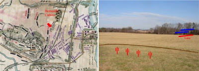 |
| From Bernard's Cabins |
A small sign along the Fredericksburg tour road marks the trail to Bernard’s Cabins. The cabins no longer exist, but I will hike any reasonable distance to see an artillery position. I’ve been fascinated by Civil War artillery since I was old enough to climb on cannons (not an endorsement, mind you). My wife can identify a Napoleon, and sometimes a Parrot Rifle. The sun was out and the temperature had reached the mid-40’s, so I set out through the woods in hopes that the gun position had not been lost to development or tree growth.
I emerged from the woods in a large clearing extending to the Richmond, Fredericksburg, and Potomac Railroad embankment and the open ground of the Slaughter Pen Farm to the east. The ground rises from the edge of the woods, forming a knoll several hundred yards from the railroad embankment. Here, Captain Greenlea Davidson directed the fire of three batteries. Bernard’s Cabins, which the gunners tore down to clear their field of fire, had been home to slaves working one of the larger plantations in the area.
Davidson’s gunners endured a fierce bombardment by Federal artillery under the command of Charles Wainwright followed by infantry assaults directed by Meade and Gibbon that. To make matters worse, one of Davidson’s batteries was supplied with defective ammunition and had to be withdrawn.
The rebel cannon were supported by troops of A.P. Hill’s division deployed to their right front along the railroad and in trenches to their rear. Meade and Gibbon exploited a gap in Hill’s lines and nearly carried his lines. James Lane’s brigade was driven back from the railroad embankment in disorder and Gibbon’s Federal troops surged into the woods beyond, threatening to turn Davidson’s gunners out of their position.
Several batteries under Latimer deployed on Davidson’s left, and a timely counterattack by Edward Thomas’s Georgia brigade. Under pressure from Thomas’s men and scathing volleys of canister from Davidson’s gunners, Gibbon’s assault lost momentum. Without support, Gibbon reluctantly withdrew his troops and Thomas, along with rallied elements of Lane’s command, reestablished the Confederate line along the railroad embankment.
The batteries under Davidson’s command maintained their position throughout the battle.
Saturday, January 10, 2009
Fredericksburg Part 1: The Sunken Road
When I last visited many years ago, the Sunken Road section below Marye’s Heights seemed like a tiny island awash in a sea of development. To some degree, it still is, but crisp days in January are ideal for visits to places where solitude and reflection must reconstruct the scene.
A walking tour affords an indelible impression of the strength of Lee’s lines. A gentle, almost imperceptible slope extends perhaps fifty yards from the Sunken Road. Here the vista ends, lost to modern development forever. But it is enough. The wall itself rises perhaps four feet from the road surface, but Lee’s men had ample time to improve their position into a formidable entrenchment.
A short walk from the Visitors Center, the Innis house still stands just a few feet from the stone wall. A bullet scarred interior wall bears silent witness to the ferocity of the combat here. A scant forty yards beyond, the Federal assaults ground to a bloody halt in the midst of the storm of fire pouring from the Sunken Road. But they did not contend against infantry alone.
Immediately behind the Sunken Road, Maryes Heights rises abruptly to an elevation of forty feet or more. From its crest, visitors can still see the spires of the two largest churches in the town of Fredericksburg. During the battle, the guns of the Washington Artillery lined the heights here. Seldom has artillery commanded a more spectacular field of fire.
Once they emerged from the town of Fredericksburg, the hapless Federal soldiers faced an advance across two thousand yards of open ground under the muzzles of the guns of the Washington Artillery at every turn. That any of them advanced within even within one hundred yards of the stone wall is a supreme tribute to their courage under fire.
The National Cemetery at Fredericksburg occupies the southern shoulder of Maryes Heights, a fitting tribute to the men who gave their lives in what must have seemed to them a pointless struggle against insurmountable odds. It is hard to excuse Burnside for his inflexible and unimaginative frontal attacks. But Abraham Lincoln gave meaning to every battlefield sacrifice with his short and eloquent address on the establishment of the National Cemetery at Gettysburg less than one year later.
One final note on my tour of the Sunken Road. The most prominent monument on the battlefield at Fredericksburg commemorates the heroism of Sergeant Richard Kirkland of the 2nd South Carolina Regiment. Kirkland, at the risk of his own life, left the safety of the rebel lines in the sunken road to comfort the federal wounded lying only yards in front of his position. In an arena of death where man’s inhumanity was so prominently displayed, Sergeant Kirkland’s actions remind us that even in the midst of bitter conflict, the “better angels of our nature” also reign.
Next Up: Fredericksburg Part 2: Franklin’s Assault
Sunday, January 4, 2009
Fredericksburg - A Study in Contrasts
 |
| From Fredericksburg |
Happy New Year to all! I started off the year with a visit to Fredericksburg. Posts on the battlefield tour are forthcoming. I have not visited this site for many years, and time has brought changes both exciting and sobering.
Once I finished the main battlefield tour, I set out for the Pelham Marker. Along the way, I passed the Slaughter Pen Farm, recently saved from development by the Civil War Preservation Trust. Surrounded by industrial and commercial properties, this tract alone affords an unobstructed view of the terrain Meade’s troops advanced across in the most successful attack of the day on Lee’s lines. The purchase of this farm is one of the great victories for battlefield preservation in recent years.
And yet just a few hundred yards away the Pelham Marker stands at a busy crossroads, hemmed in by a CVS on one corner, and the Pelham’s Corner Rite-Aid and gas station on another. Here, Pelham advanced well in front of Lee’s lines and directed the fire of two guns against the flank of Franklin’s assault. Pelham drew the fire of several Federal batteries and delayed the Union assault for over 30 minutes. With one gun out of action, he shifted position repeatedly and kept firing with his remaining Napoleon, ignoring calls to return to his lines and retiring only when his ammunition was nearly exhausted. Lee witnessed this brave and reckless display and commented “It is glorious to see such courage in one so young.”
To be fair, the developers reserved a small plot for the original stone marker and two interpretive signs donated by a corporate sponsor. But any impression of Pelham’s vantage point or the field of fire of his intrepid gunners exists now only in the mind’s eye. And so Fredericksburg offers a study in contrasts. Many areas of the battlefield lie almost untouched by development, while others have been lost forever. With this in mind, I thought it fitting to open the year with a few thoughts on the importance of preservation. Please support the efforts of the Civil War Preservation Trust and your local preservation groups this year.
Subscribe to:
Posts (Atom)


