Monday, June 30, 2008

Antietam: The Final Attack Trail Part 2


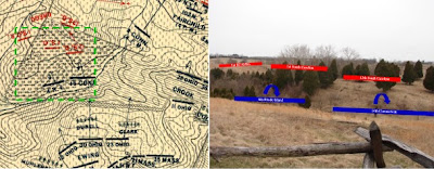
The men of Ewing’s Brigade of the Kanawha Division steadied themselves behind the fence rails along the Otto farm lane as men of the 16th Connecticut and 4th Rhode Island streamed past. The Ninth Corps’ flank, and the success of their drive toward Sharpsburg, threatened to unravel under the relentless pressure of A.P. Hill’s slashing attacks. As Gregg’s South Carolinians drove eastward through the 40 Acre Cornfield, Archer’s Brigade formed along the Harper’s Ferry Road and prepared to join the fray.

The 23rd and 30th Ohio regiments of Ewing’s brigade scaled the fence in their front and steeled themselves to repel the rebels closing in from the south and west. The 23rd Ohio drove westward just to the north of the corn, while the 30th Ohio moved to the bottom of the ravine, entered the corn, and drove up the opposite slope. Once more, however, confusion reigned in the Federal ranks, and the 12th Ohio failed to advance with the rest of the brigade. Both the 23rd and 30th Ohio halted at the stone wall bordering the western end of the cornfield and poured a telling fire into the flank of the 7th and 37th North Carolina regiments of Branch’s Brigade, the second of A.P. Hill’s units to reach the field. The North Carolina regiments recoiled under this fire, but support was not far behind.

Archer’s tiny brigade of Hill’s division, reduced to less than 400 men by the grueling march from Harper’s Ferry, drove west from the Harpers Ferry road and charged the stone wall manned by Ewing’s Ohio regiments. At first, the Ohio boys held their own. Gregg’s men, however, still held the southern and western portions of the cornfield, and increased the pressure on the Ohioan’s flank until the position at the wall became untenable. Ewing refused his left flank, facing the 23rd and several companies of the 30th Ohio to the southwest. Other companies of the 30th Ohio retired east toward the Otto Farm Lane, where they mingled with remnants of the 16th Connecticut of Harland’s brigade.

Ewing’s last regiment, the 12th Ohio, nearly broke under a prolonged fire of infantry and artillery, some of it from friendly batteries. At length, the regiment took position along the western fence line of the Otto Farm Lane, unwilling to advance into the teeth of Gregg’s veterans, convinced that the same unhappy fate that befell Harland’s regiments awaited them in the broad expanse of corn to their front.

As dusk settled over the smoke filled ravines of the Otto Farm, Gregg’s men consolidated their position. Sturgis’s division of the Ninth Corps, having replenished its ammunition after its fight for the Rohrbach Bridge, relieved Ewing’s hard pressed brigade and took position along the Otto Farm Lane, facing west. These Federals engaged Archer’s and Gregg’s men with a desultory fire until dusk put an end to the contest.

A. P. Hill’s driving counterattack had unraveled the Ninth Corps offensive. Hill’s veterans exploited the rugged, confused terrain south of Sharpsburg and fought with determination and vigor. Behind the scenes, Lee himself drove every serviceable gun he could find into action along the ridge crowned by the Harpers Ferry Road, while McClellan, fretting precious hours away at the Pry House east of Antietam Creek, sent only a single battery to support the Ninth Corps in its hour of need.

Darkness brought an end to the fighting. Though Burnside expressed his willingness to continue the fight on the morrow if properly supported, McClellan would let September 18th pass without action. Lee’s army withdrew across the Potomac the following day, and but for a short, sharp action at the ford below Shepherdstown, the Maryland campaign was over.

Wednesday, June 25, 2008

The New Gettysburg Visitors Center

I visited the new Gettysburg Visitor’s Center this past week with a few family friends. Like many of you, I suspect, I am often called on to give tours at Antietam or Gettysburg for relatives and friends. This was my third visit to the new facility. We spent just over two hours there and skipped most of the Gettysburg Address exhibits to save time for walking the field.

The museum offers a much broader perspective of the war and the exhibits are more topical than the previous museum’s long ranks of muskets and rifles. I do miss the old weapons displays, but they survive in a limited form, and there are numbers of them scattered about in thematic displays. Overall, the presentation has improved dramatically.

Short films provide introductions to each day’s fighting, summaries of the war prior to and after Gettysburg, and an overview of slavery and its impact on American society. The latter film may not sit well with the states rights crowd. The battle films use animated maps to detail the action. Presentation is geared toward general interest in every case. Controversies and regimental detail are lacking, but I tend to agree with the targeting of exhibits toward a general audience. After all, before I was a buff, I was a kid with a copy of They Met at Gettysburg, and it was all new to me.

The exhibits are generally good, but several stand out for me. Interactive touch-screen displays allow you to select any regiment and find its location on the field, along with a picture of its monument. Plaques display the formations and tactics of each service branch using drawings reminiscent of the old American Heritage battle diagrams (or the more recent Battle in the Civil War by Paddy Griffith). Finally, the Pickett’s Charge exhibit includes three displays relating the experience of the men as they marched toward the Union lines. Plaques explain the weapons bearing on them at various distances, and cases filled with shell fragments, bits of fuse, and bullet fragments immerse the viewer in an impression of the destructive power of concentrated infantry and artillery fire.

After three visits and perhaps six hours spent in the new museum, I am favorably impressed with both the quality and quantity of the exhibits. Definitely worth a visit, even if you have been to Gettysburg many times before. And it’s not only the new Visitors Center – the battlefield itself has changed dramatically in recent months. The NPS landscape restoration program has turned back the clock on the field of the second day’s battle around Little Round Top and Devil’s Den to 1863. I will be visiting again soon to explore the field and will post my impressions here, along with a few pictures.

Next Up: Antietam’s Final Attack Trail Part 2 (finally)!

Sunday, June 15, 2008

Antietam: The Final Attack Trail Part 1


On a recent visit to Antietam Battlefield I hiked the Final Attack Trail for the second time. The trail winds across the Otto Farm and the Forty Acre Cornfield, a tortured landscape of deep ravines and sharp elevations. Here, the advance of the Federal Ninth Corps unraveled under the pressure of a slashing flank attack by veterans of AP Hill’s Light Division in the final act of the bloodiest day in American history.

I set off with my backpack stuffed with books, maps, and a bottle of water. I carried along Carmen’s history of the campaign, Antietam: The Soldier’s Battle, and the War College guide. For hikes at Antietam, I always carry Trailhead Graphics’ battlefield contour map, and I also printed out two detailed views of the area extracted from the Carmen-Cope maps of the situation at 3:30pm and 4:20pm (these include unit positions). More on the Carmen-Cope maps in a later post. Many thanks to Antietam on the Web, where I first learned of this excellent resource. A narrative of the action as I understand it follows.

Harland’s Brigade of Rodman’s Division held the extreme left of the IX Corps line. The 11th Connecticut regiment of the brigade, recovering from its costly skirmish at the Rohrbach Bridge, remained behind. The 4th Rhode Island deployed on the left, the green 16th Connecticut in the center, and the 8th Connecticut on the right, linking up with Fairchild’s Brigade (see map above).

The two left regiments advanced into the ravine on the eastern end of the Forty Acre Cornfield and halted to await further orders, while the 8th Connecticut continued to advance along with Fairchild’s men. A gap opened in the center of the brigade just as Hill’s Division arrived on the scene. Gregg’s veteran South Carolina brigade seized the high ground at the southern and western edges of the cornfield (see picture map above).

One of Gregg’s regiments carried a flag that appeared to be the stars and stripes. Two officers and a color bearer from the 16th CT moved forward to investigate. Gregg’s men shot down the 16th CT’s color bearer within yards of their position and the two officers sprinted back to the regiment. Some of Gregg’s men may have been wearing coats or trousers from Federal uniforms captured at Harper’s Ferry, though whether this was apparent in the head high corn is debatable.

As Gregg’s men advanced, they unleashed a scathing volley. The Connecticut men had never loaded their rifles and had mastered only the rudiments of drill, a situation all too common in the Army of the Potomac in this campaign. Men fell, confusion reigned, orders were misunderstood. The 16th broke and ran to the rear, dragging the right wing of the 4th Rhode Island along with them in their haste to escape.

Ewing’s Brigade of the Kanawha Division was close behind in support of Rodman’s Division. As the demoralized men of the 16th CT and 4th RI streamed past, the security of the IX Corps flank, and the fate of its offensive, passed into their hands. More on that in my next post.

Thursday, June 12, 2008

Fire on the Mountain

This past Saturday, June 7, my wife and I headed to Fox's Gap on South Mountain for "Fire on the Mountain." Confederate artillery crews serving a battery of four Napoleon cannon demonstrated arillery drill and simulated counterbattery fire against a Federal battery deployed some 600 yards away. The rebels occupied the position held by Bondurant's battery during much of the fighting for Fox's Gap on September 14, 1862.

We started the day at Turners's Gap on Alt 40 near the South Mountain Inn (known as the Mountain House in battle reports). From there, the Applachian trail winds southward along the crest of South Mountain to Fox's Gap. The trail runs along the route of an old logging path known as the Wood Road, and was used by various rebel units moving to the defense of Fox's Gap.

The rebel battery demonstrated firing by piece and by section, followed by a tactical simulation of counterbattery fire and defense against infantry. The boom of the big brass guns echoed across the mountainside, hinting at the din of battle long ago in September, 1862. The heat was intense, the temperature approaching 100 degrees at mid-day. Many thanks to the reeanactors who carried out their drill commands with clarity and precision in an open field undert the hot sun while many spectators struggled to find a shady spot to watch the demontration. Thanks also to the property owner. Much of the battlefield is still in private hands, and without the generosity of these fine folks, events like "Fire on the Mountain" would not be possible.

Note: I added a slideshow above using Picasa by Google. Enjoy the photos!

Wednesday, June 4, 2008

A New Civil War Blog for Battlefield Enthusiasts

Civil War Battles and Battlefields will feature travel narratives of my frequent visits to historic sites and my thoughts on recent readings in Civil War history and historiography. I live in central Maryland, an ideal location for a Civil War buff. Gettysburg, Antietam, Harper’s Ferry, South Mountain, and Monocacy are all within an hour’s drive, and most of the Virginia battlefields are within easy day trip range.

I hope to convey some of my enthusiasm for these places, to give those who cannot visit these sites as often as I do a chance to experience the excitement of walking in the footsteps of the men who fought in these places over a century ago.

I will include photos and maps occasionally to enhance the sense of place in my travel pieces. In my opinion, the best site for photos of Civil War sites on the net is http://www.civilwaralbum.com. If you have not seen this site before, you are in for a real treat. So I won’t be posting virtual tours; rather, I hope to create specific impressions.

More often than not, my posts will focus on a narrow aspect of a particular battle. Generalists will find books and magazines more useful, perhaps. Occasionally, I may cover living history events, museums, preservation issues, or interesting Civil War sites on the net. I plan to post once per week during Spring and Summer, and semi-monthly during the colder months. Posts will average 500 words or less.

The first series of posts will narrate my recent explorations of Antietam Battlefield’s Final Attack Trail, where A.P. Hill’s Light Division pitched into the flank of Burnside’s IX Corps, snatching away the last, and possibly best, chance for a decisive Federal victory at Antietam.
Enjoy Civil War Battles and Battlefields. I welcome your comments, questions, and criticisms.