Showing posts with label Harpers Ferry. Show all posts

Sunday, August 8, 2010

SHAF Tour - Harpers Ferry

From SHAF Tour 2010

I will cover the SHAF tour of South Mountain and Harpers Ferry in several posts focused on the various separate engagements covered by the tour. An overview of Harpers Ferry seems appropriate to start, what with the concern over development plans for Bolivar Heights. The picture above shows the position of A.P. Hill's artillery on the Murphy Farm. Hill's seizure of this position flanked Bolivar Heights and sealed the fate of the garrison. It is worth noting the Murphy Farm represents a significant preservation victory made possible by the cooperation of the NPS and the Murphy family.

One of the themes of the tour highlighted the need to reappraise the performance of Federal and Confederate commanders during the campaign. Dixon S. Miles, the Federal commander at Harpers Ferry, is almost universally regarded as an "imbecile," but as Dr. Dennis Frye points out, he was forced to defend the town. His choices of Maryland Heights and Bolvar Heights for defensive positions made the best of a bad situation. Miles had perhaps 14,000 troops, most of which were green, and many of them had been in the army for only 3 weeks - barely enough time to learn how to load and fire a musket, let alone maneuver in formation.

The loss of Maryland Heights to troops under Lafayette McLaws seriously compromised Miles's defense, but this was perhaps unavoidable given the inexperience of Miles's command. With hope for relief fading, Miles permitted 1400 cavalry under Colonel Grimes Davis to attempt a breakout. The cavalry had been posted on the Murphy farm, guarding the southern flank of Miles's defensive line. As the cavalry made their escape in darkness, the infantry sent to replace them was recalled to Bolivar Heights to shore up the main line against an apparent night assault.

This night assault was a diversion planned by Jackson to cover the advance of A. P. Hill's division to the Murphy Farm, and it worked brilliantly. Frye considers this one of Jackson's most ingenious strategems, and suggests that Jackson receives little credit for it because of the low opinion most historians hold of his opponent. Given a reappraisal of Miles's efforts, Jackson's success at Harpers Ferry attains new significance. He coordinated three separate columns in a difficult convergence, disrupted his opponents defensive arrangements with a clever ruse, and seized a key position that made the enemy's line, and ultimately the town of Harpers Ferry, untenable. His efforts resulted in the largest surrender of U.S. forces prior to World War II.

Today, Harpers Ferry National Historic park includes portions of School House Ridge, Bolivar Heights, the Murphy Farm, and Maryland Heights. The battlefield portions of the park exist through the combined efforts of private individuals, CWPT, and the National Park Service. As I rethink my own opinions of Miles and Jackson's operations before Harpers Ferry, I am grateful for the areas that have been preserved, and hopeful for those that have not.

Wednesday, August 4, 2010

Harpers Ferry Update from CWPT

From SHAF Tour 2010

As noted in my earlier post, I received a rapid response to an email I sent to CWPT about the risk to Bolivar Heights at Harpers Ferry. Here's the situation as described by Jim Campi of CWPT:

"CWPT is part of a coalition of groups that is fighting to save of the Old Standard Tract. The coalition has won a few fights to prevent development of this key property over the past 5-6 years. But, as you know, we have to win EVERY attempt to develop this historic parcel – the developers only have to win once."

Jim also forwarded a notice about several local meetings to raise awareness and determine courses of action to combat the backhanded and arbitrary methods used by the developer and the State of West Virginia that usurped zoning juridiction from the local government:

----------
STATE OF WEST VIRGINIA PREEMPTS LOCAL GOVERNMENTS

Developers of the Old Standard Quarry twice tried to upgrade the density of use, and thus the value, of the nearly 400-acre Old Standard Quarry on the edge of Harpers Ferry. Annexation to the City of Charles Town some five miles distant was tried without success. They also sought rezoning from Jefferson County without success. Then it recently was discovered that they had quietly pushed through state legislation that exempted “brownfield districts” from state planning and zoning laws, and had regulations implemented making themselves governments unto themselves free to develop the land any way they wished free of local control. The scheme was only exposed when it was discovered that a final plat subdividing the property for over 2,000,000 square feet of commercial space had been recorded in June 2010.

ACT NOW! YOUR PARTICIPATION AND ATTENDANCE IS ESSENTIAL!

The Jefferson County Commission is working hard to unravel these schemes through Freedom of Information Act (FOIA) requests, and other means, and has scheduled two important meetings with the state delegation to figure out how these circumstances came about and how to reverse course and restore local planning control. Here’s the schedule:

August 16 (Monday) 3:00-5:00 p.m. Overview of Old Standard Application for “Brownfield District” designation.
August 19 (Thursday) 3:00 p.m. for discussion with state delegation about how this legislative scheme evolved

Both meetings are at the Charles Town Library at the corner of Washington and Samuel Streets in Charles Town, West Virginia

A STRONG SHOWING OF CITIZEN SUPPORT IS ESSENTIAL TO BACK UP OUR LOCAL OFFICIALS. BRING YOURSELF, BRING YOUR FRIENDS!
BE THERE AND BE PART OF A SHOW OF SOLIDARITY!

----------

What can you do? 1. Attend the meetings, if possible. 2. Support CWPT. They understand the situation and context and have been involved with local organizations in the struggle against this development threat for the past several years.

What's in this for you besides preserving hallowed ground? I will send Guild Press's The Civil War CD-ROM to the first person to email me at cwbattlefields@gmail.com a donation receipt from CWPT dated on or after August 5, 2010 in the amount of $50.00 or more. The CD contains the Army Official Records and a few aditional supporting works. Who can't use a digitized copy of the OR's?

Harper Ferry Update

I received a response from Jim Campi of CWPT this morning. They are working on this one, and Jim forwarded some information on local meetings being held to discuss this issue. I will post the details later today.

I am also trying out a Blogger app
for my new Droid. I'm hoping it will come in handy on my upcoming Civil War weekend.

Published with Blogger-droid v1.4.9

Monday, August 2, 2010

The Siege of Harpers Ferry 2010

From SHAF Tour 2010

Colonel Dixon S. Miles positioned his Federal troops along Bolivar Heights to defend Harpers Ferry against Stonewall Jackson's wing of the Army of Northern Virginia. He faced long odds in what many historians consider an indefensible position.

We face those same odds today in the wake of development plans for the section of Bolivar Heights pictured above. The cleared section of the ridge has been slated for industrial / commercial development. In the words of Dr. Dennis Frye, "picture a super-Wal-Mart, then picture 16 buildings of that size and cover that ridge in the distance with them." This is the threat.

If you had heard the passion in Dennis's voice when he spoke about this, you would understand his frustration with recent attention given to the Wilderness Wal-Mart, sited close to the Wilderness Battlefield, when actual battlefield land at Harpers Ferry is about to be paved over and lost forever.

How we got to this point is irrelevant. And it's possible this battle may be lost. The zoning is in place and the preservation community does not seem to be mobilized for this fight. So consider this a call to action. As soon as I find out more, I will post it here. Let's hope CWPT is aware of this crisis and planning a campaign to prevent the destruction of a critical portion of a battlefield that witnessed the largest surrender of united States forces prior to World War II.

UPDATE: Check out Harry Smeltzer's post over at Bull Runnings, which has some additional detail on the developers responsible for this mess.

Friday, July 30, 2010

SHAF Tour – Phase One of the Antietam Campaign: Harpers Ferry and South Mountain

Most of the Summer has slipped by without any major battlefield visits. Happily, this is about to change. Tomorrow I set out with SHAF (Save Historic Antietam Foundation) on a tour of Harpers Ferry and South Mountain, led by Dr. Dennis Frye and Dr. Tom Clemens. Details are available on the SHAF site (the tour is almost certainly closed at this point).

I expect to blog the tour in detail, despite my inactivity here of late. I am also in the planning stages for my annual Civil War weekend later in August. This year’s focus will be the Burnside Expedition of 1862 on the North Carolina Coast, with visits to Forts Fisher and Anderson outside Wilmington as well. I finally found a copy of Richard A. Sauers’s A Succession of Honorable Victories: The Burnside Expedition of 1862, which looks to be the only detailed monograph on the campaign. I always like to read as much as I can before I set out, so I know what I’m staring at.

In any case, I can't wait to spend some time in the field.

Thursday, May 14, 2009

A Matter of Interpretation

While browsing the Harpers Ferry NPS site to plan a hike of Maryland Heights, I learned the park houses the Harpers Ferry Center. The center develops Long Range Interpretive Plans for other park units. One recently developed plan outlines changes for Fort Donelson National Battlefield (this is a PDF file).

I have not read the plan in its entirety, but did note several items of interest. The plan recognizes an increasing lack of historical knowledge among general visitors, a need for modernization, and a lack of interpretive resources and staff (professional and volunteer). The plan also argues that interpretation must recognize the larger impact of the battle on slaves, civilians, and women, rather than focus simply on the military aspects of the site. Couched within these arguments is the conviction that the cultural shifts change not only the questions we ask of history, but the relevance of various aspects of it.

I applaud a more comprehensive interpretive approach so long as the war and the battlefield itself are not de-emphasized to the point of insignificance in the quest for cultural relevance. I am reminded of the debate on the new museum at the Gettysburg visitors center. I am all for a comprehensive approach to interpretation that still recognizes the paramount importance of the specific site and the battlefield in question. The new Gettysburg facility does so, with one exception. I was disappointed by the decision to display such a limited portion of the artifacts available in the park’s collection, and the assumption that large displays of firearms or other artifacts are somehow not important. In light of that, I would offer this plea: in the effort to ensure that no group is marginalized by the interpretive efforts of these sites, let’s not forget the good-old-fashioned Civil War buffs who visit these places regularly year after year, and who think that the stories of these battles and the soldiers who fought them are worth telling and re-telling from generation to generation.

Monday, July 7, 2008

The Siege of Harpers Ferry


Harper’s Ferry offers a unique combination of scenic beauty, history, and entertainment. It’s a great place for a day trip. In fact, I drove to Harper’s Ferry twice over July 4th weekend. To be honest, the first trip was a washout – it poured from the minute I crossed into West Virginia. Since we live less than an hour away, I decided to try again the next day.

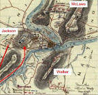
Confederate troops opened their siege of Harper’s Ferry in September 1862 with a three pronged effort to capture the commanding elevations surrounding the town. McLaws seized Maryland Heights to the north, driving the Federal garrison pell-mell down the slope and across the bridges to the town. Walker’s Division occupied Loudon Heights to the south. Jackson’s troops invested the Federal position on Bolivar Heights from Schoolhouse Ridge to the west.

I first hiked along the Federal skirmish line between Bolivar Heights and North Schoolhouse Ridge, where three green New York regiments spent an uneasy night on the line awaiting a frontal attack that never came. Jackson had something else in mind. He sent a column under A. P. Hill to outflank Bolivar Heights from the south. Hill placed several batteries to enfilade Bolivar Heights, and after a sharp morning bombardment, his infantry started their advance. White flags appeared in the Federal lines as the infantry closed in.

On Bolivar Heights, Union Colonel Dixon S. Miles, commanding Harpers Ferry, determined further resistance was useless. Shortly thereafter, he was mortally wounded by one of the last salvos from the rebel artillery. The Federals never should have attempted to defend Harpers Ferry in the first place. Once the rebels seized Maryland and Loudon Heights, the contest was simply a matter of time. Looking from Bolivar Heights to the dominating summits of the other elevations to the east, the indefensibility of the post is clear. What McLellan may have done with the 12,000 troops surrendered here is a matter of speculation. He certainly made no strenuous effort to save them from the trap.

The trails along Bolivar Heights offer excellent views of Shoolhouse Ridge, Maryland Heights, and Loudon Heights. Take a map, and start at the Bolivar Heights area on Washington Street just off Route 340. I started my hike without a map from the Federal skirmish line area at the western end of Bolivar Heights, and ended up walking the trails between the two areas. The drive between is much easier, and you won’t miss anything. I plan to take in the southern end of Schoolhouse Ridge and Maryland Heights on my next visit.