Wednesday, March 25, 2009

Fredericksburg Part 2: Franklin's Assault

As you follow the tour road South and leave behind the determination and despair of the struggle for the Sunken Road, Fredericksburg becomes quite a different battlefield. Thoughts of senseless slaughter at the foot of Marye’s Heights give way to considerations of lost opportunities.

The center of Lee’s position was nearly unassailable, anchored on the commanding height of Howison’s Hill. Here Lee positioned his headquarters and also placed the army’s largest field pieces – a pair of 30 pound Parrott Rifles. The lunettes constructed for these pieces still exist, though the view from both sites is now largely obscured by tree growth. The tour road runs through modern woods along the remains of the earthworks that run the entire length of Lee’s lines, so the view from your car seat is limited at best.

Dismount for the trail to Bernard’s Cabins (see my previous post), as well as the site where Meade’s division breached A.P. Hill’s line and Brigadier General Maxcy Gregg received a mortal wound attempting to stem the tide of the Federal advance. Note the ravine just within the tree line descending eastward. At the time of the battle, the ravine descended to a marshy area considered impassible to attacking troops. Hill left this area largely uncovered, and Meade’s attacking troop exploited the gap, finding the march was not such an obstacle as the rebel commander thought. Had Meade received timely support, perhaps the Federal effort here would have turned the tide of battle against Lee.

Continuing South, you emerge from the woodline along the slopes of Prospect Hill, where Jackson deployed the bulk of his artillery. The hill ascends sharply from the gently rising plain to the east. Though trees now cover much of the field, the railroad embankment perhaps two hundred yards from Jackson’s position afforded the only protection available to attacking Federals during their assault.

The monument across the tracks at the base of the hill, popularly known as the Meade Pyramid, was actually one of several erected by the railroad after the war to mark sites of historical significance along its lines. Meade’s troops penetrated Hill’s lines just to the north of the pyramid.

The guns lining Prospect Hill to the south mark the right of Jackson’s position. These guns had a commanding view of much of the plain to the east where Franklin’s troops formed up, and yet the area was nicknamed “Dead Horse Hill” as a testament to the effectiveness of the Federal bombardment prior to their attack. Stuart’s cavalry and additional artillery extended the line to the east in a broad arc encompassing the area of the Federal deployment. Far out in front of the right flank, John Pelham fought two guns with such effectiveness and against such extreme odds that Robert E. Lee marveled to see “such courage in one so young.” See my previous post on the Pelham marker for details.

The battlefield of Fredericksburg truly presents as study in contrasts. While development has encroached upon the Sunken Road and Pelham’s Corner, the recent acquisition of the Slaughter Pen Farm on the southern part of the field represents one of the most significant preservation victories in recent memory. And while Burnside wasted the lives of his men in fruitless assaults against Marye’s Heights, Franklin squandered the Federals’ one real opportunity to win the battle, failing to support Meade’s breakthrough and turning in a generally mediocre performance. In the end, this battle was indecisive, another misstep for Lincoln along the path toward an effective commander for the Army of the Potomac. Nevertheless, there are few sites that inspire reflection and appreciation of courage and sacrifice like the sunken road and the stone wall at the base of Marye’s Heights.

Friday, March 20, 2009

Signs of Life

Winter is finally over, and I hope my long absence from this blog is as well. I am working on the last post for my Fredericksburg trip in January and also a mini-review of Wilson's Creek, a great book by William Piston and Richard Hatcher III featuring detailed coverage of the battle and an analysis of unit loyalties and identities in early war armies.

This weekend also marks the beginning of my Spring hiking schedule. The staff at Antietam began last week with a hike focusing on the Irish Brigade (I missed this one). This week's hike will explore Confederate artillery positions on and around Nicodemus Hill, and offers a rare opportunity to explore privately held land. I'm told Brian Baracz is leading this one, so I expect to cover some challenging terrain (briars, steep slopes -- who knows). He also has a knack for selecting poignant vignettes from memoirs and diaries to highlight the significance of otherwise unobtrusive terrain features, so I'm looking forward to it.

The hike starts at the North Woods stop around 1:15pm on Sunday. Hope to see you there!

Tuesday, January 20, 2009

Off the Beaten Path at Fredericksburg: The Bernard's Cabins Trail

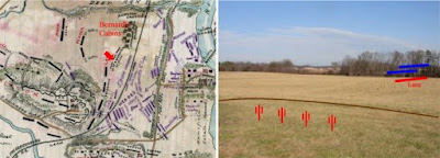
From Bernard's Cabins


A small sign along the Fredericksburg tour road marks the trail to Bernard’s Cabins. The cabins no longer exist, but I will hike any reasonable distance to see an artillery position. I’ve been fascinated by Civil War artillery since I was old enough to climb on cannons (not an endorsement, mind you). My wife can identify a Napoleon, and sometimes a Parrot Rifle. The sun was out and the temperature had reached the mid-40’s, so I set out through the woods in hopes that the gun position had not been lost to development or tree growth.

I emerged from the woods in a large clearing extending to the Richmond, Fredericksburg, and Potomac Railroad embankment and the open ground of the Slaughter Pen Farm to the east. The ground rises from the edge of the woods, forming a knoll several hundred yards from the railroad embankment. Here, Captain Greenlea Davidson directed the fire of three batteries. Bernard’s Cabins, which the gunners tore down to clear their field of fire, had been home to slaves working one of the larger plantations in the area.

Davidson’s gunners endured a fierce bombardment by Federal artillery under the command of Charles Wainwright followed by infantry assaults directed by Meade and Gibbon that. To make matters worse, one of Davidson’s batteries was supplied with defective ammunition and had to be withdrawn.

The rebel cannon were supported by troops of A.P. Hill’s division deployed to their right front along the railroad and in trenches to their rear. Meade and Gibbon exploited a gap in Hill’s lines and nearly carried his lines. James Lane’s brigade was driven back from the railroad embankment in disorder and Gibbon’s Federal troops surged into the woods beyond, threatening to turn Davidson’s gunners out of their position.

Several batteries under Latimer deployed on Davidson’s left, and a timely counterattack by Edward Thomas’s Georgia brigade. Under pressure from Thomas’s men and scathing volleys of canister from Davidson’s gunners, Gibbon’s assault lost momentum. Without support, Gibbon reluctantly withdrew his troops and Thomas, along with rallied elements of Lane’s command, reestablished the Confederate line along the railroad embankment.

The batteries under Davidson’s command maintained their position throughout the battle.

Saturday, January 10, 2009

Fredericksburg Part 1: The Sunken Road

When I last visited many years ago, the Sunken Road section below Marye’s Heights seemed like a tiny island awash in a sea of development. To some degree, it still is, but crisp days in January are ideal for visits to places where solitude and reflection must reconstruct the scene.

A walking tour affords an indelible impression of the strength of Lee’s lines. A gentle, almost imperceptible slope extends perhaps fifty yards from the Sunken Road. Here the vista ends, lost to modern development forever. But it is enough. The wall itself rises perhaps four feet from the road surface, but Lee’s men had ample time to improve their position into a formidable entrenchment.

A short walk from the Visitors Center, the Innis house still stands just a few feet from the stone wall. A bullet scarred interior wall bears silent witness to the ferocity of the combat here. A scant forty yards beyond, the Federal assaults ground to a bloody halt in the midst of the storm of fire pouring from the Sunken Road. But they did not contend against infantry alone.

Immediately behind the Sunken Road, Maryes Heights rises abruptly to an elevation of forty feet or more. From its crest, visitors can still see the spires of the two largest churches in the town of Fredericksburg. During the battle, the guns of the Washington Artillery lined the heights here. Seldom has artillery commanded a more spectacular field of fire.

Once they emerged from the town of Fredericksburg, the hapless Federal soldiers faced an advance across two thousand yards of open ground under the muzzles of the guns of the Washington Artillery at every turn. That any of them advanced within even within one hundred yards of the stone wall is a supreme tribute to their courage under fire.

The National Cemetery at Fredericksburg occupies the southern shoulder of Maryes Heights, a fitting tribute to the men who gave their lives in what must have seemed to them a pointless struggle against insurmountable odds. It is hard to excuse Burnside for his inflexible and unimaginative frontal attacks. But Abraham Lincoln gave meaning to every battlefield sacrifice with his short and eloquent address on the establishment of the National Cemetery at Gettysburg less than one year later.

One final note on my tour of the Sunken Road. The most prominent monument on the battlefield at Fredericksburg commemorates the heroism of Sergeant Richard Kirkland of the 2nd South Carolina Regiment. Kirkland, at the risk of his own life, left the safety of the rebel lines in the sunken road to comfort the federal wounded lying only yards in front of his position. In an arena of death where man’s inhumanity was so prominently displayed, Sergeant Kirkland’s actions remind us that even in the midst of bitter conflict, the “better angels of our nature” also reign.

Next Up: Fredericksburg Part 2: Franklin’s Assault

Sunday, January 4, 2009

Fredericksburg - A Study in Contrasts

From Fredericksburg


Happy New Year to all! I started off the year with a visit to Fredericksburg. Posts on the battlefield tour are forthcoming. I have not visited this site for many years, and time has brought changes both exciting and sobering.

Once I finished the main battlefield tour, I set out for the Pelham Marker. Along the way, I passed the Slaughter Pen Farm, recently saved from development by the Civil War Preservation Trust. Surrounded by industrial and commercial properties, this tract alone affords an unobstructed view of the terrain Meade’s troops advanced across in the most successful attack of the day on Lee’s lines. The purchase of this farm is one of the great victories for battlefield preservation in recent years.

And yet just a few hundred yards away the Pelham Marker stands at a busy crossroads, hemmed in by a CVS on one corner, and the Pelham’s Corner Rite-Aid and gas station on another. Here, Pelham advanced well in front of Lee’s lines and directed the fire of two guns against the flank of Franklin’s assault. Pelham drew the fire of several Federal batteries and delayed the Union assault for over 30 minutes. With one gun out of action, he shifted position repeatedly and kept firing with his remaining Napoleon, ignoring calls to return to his lines and retiring only when his ammunition was nearly exhausted. Lee witnessed this brave and reckless display and commented “It is glorious to see such courage in one so young.”

To be fair, the developers reserved a small plot for the original stone marker and two interpretive signs donated by a corporate sponsor. But any impression of Pelham’s vantage point or the field of fire of his intrepid gunners exists now only in the mind’s eye. And so Fredericksburg offers a study in contrasts. Many areas of the battlefield lie almost untouched by development, while others have been lost forever. With this in mind, I thought it fitting to open the year with a few thoughts on the importance of preservation. Please support the efforts of the Civil War Preservation Trust and your local preservation groups this year.

Monday, December 29, 2008

Antietam 146th Anniversary Commemoration, Part 4 - The I and XII Corps at Antietam

The quiet, pastoral setting of the Cornfield and East Woods at Antietam National Battlefield stands in stark contrast to the ferocity of the struggle waged by veterans of the Army of Northern Virginia against some of the most experienced and greenest troops in the Army of the Potomac. Here the Iron Brigade and the Pennsylvania Reserves faced the likes of Hood’s Texans and the Louisiana “Tigers.”

The Federal I Corps under Major General “Fighting” Joe Hooker and the XII Corps under Major General Joseph K. Mansfield, fresh from a desk in Washington, crossed the Antietam at the Upper Bridge and nearby fords and advanced to attack Jackson’s wing of Lee’s army.

After a short discussion of the advance of the I Corps from the area of the North Woods, Brian guided us through the East Woods and across the fields where the men of the XII Corps deployed. Brian has a real knack for finding challenging terrain to explore. Here, it mostly consisted of a few briars and tall grass soaked with the morning dew. We paused to consider Mansfield’s foolhardy and fatal attempt to stop his troops from firing into their own men, only to suffer a mortal wound after discovering the men in his front were indeed the enemy.

The XII Corps was a patchwork organization built upon the nucleus of Banks’s corps, men who had fought with varying degrees of success against Jackson’s men in the Valley. New regiments joined the corps prior to Antietam, often exceeding the existing strength of their parent brigades. To describe these new men as green understates the sad fact that many had yet to master even the rudiments of military drill. And yet several of these regiments fought tenaciously when not called upon to execute complex maneuvers.

As we tramped back through the East Woods toward the southeast corner of the Cornfield, Brian discussed the open nature of the managed woodlots framing this section of the battlefield. He also paused here to consider the experience of the 6th Georgia Infantry. This regiment sustained horrific losses resisting the advance of XII Corps through the woods and the increasing pressure of Federal infantry battling for control of the Cornfield.

The hike concluded with an overview of the fighting in the Cornfield. I will be covering the Cornfield in more detail next year once the weather warms and I am able to get in a few more hikes. We returned to our starting point in the North Woods with a greater appreciation of the efforts of the men of the Union I and XII Corps in one of the fiercest struggles of the war.

Sunday, December 28, 2008

The Christmas Stocking

Our family scaled back a bit for Christmas this year, but my stocking nevertheless contained two gems I look forward to reading in the new year. The first, Antietam, South Mountain, and Harpers Ferry: A Battlefield Guide, by Ethan S. Rafuse, will be handy as I plan to expand my study of the Antietam campaign and to cover the battlefield itself in more depth next year. I also received Cox: Personal Recollections of the Civil War-West Virginia, Kanawha Valley, Gauley Bridge, Cotton Mountain, South Mountain, Antietam, the Morgan Raid & the East Tennessee Campaign - Volume 1. I’ve had Jacob D. Cox's memoir on my Amazon wish list for some time now, so it is a welcome addition to my library. I often pass by the sites of Kanawha Valley campaign on my way to visit relatives in West Virginia. I hope to include some of these sites in my postings next year as well.

A belated Merry Christmas to all and best wishes for a happy and successful New Year. I am polishing up my final posts on the Antietam Anniversary hikes and will post them shortly.