 |
| From West Woods |
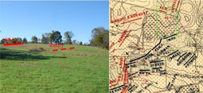
Marion “Vince” Armstrong’s recent work, Unfurl Those Colors, presents an unconventional and perhaps controversial analysis of the role of Major General Edwin V. Sumner and the Second Corps of the Army of the Potomac in the battle of Antietam. On October 11, Vince guided a tour of the West Woods and Bloody Lane for members of the Save Historic Antietam Foundation, relating his conclusions with particular attention to the impact of the terrain on the events of September 17, 1862.
The tour began at and then proceeded to Cornfield Avenue at the historical western boundary of the East Woods. As a prelude, Vince discussed Sumner’s initial reconnaissance of the battlefield, which is critical to understanding the deployment of his corps. Among the gentle slopes marking the northern part of the battlefield are several commanding elevations not apparent at first glance. One of these, at the junction of the Mumma Farm Lane and the Smoketown Road, offered Sumner a clear view of the western leg of Bloody Lane, the swale northeast of the Dunker Church where Greene’s Division was deployed at the time, and the advance of the 125th Pennsylvania into the southern terminus of the West Woods.
As Sumner moved to the north along the edge of the East Woods, he noted the noise and smoke from firing in the northern edge of the West Woods, and decided to advance Sedgwick’s Division to the West Woods to secure it prior to a general advance toward the town of Sharpsburg from the north and west, as ordered by McClellan. We followed Vince along the general route of advance of Sedgwick’s troops to the position of the 1st Minnesota at the northwestern edge of the West Woods, then moved southeast through the woods to the 15th Massachusetts monument. Vince argues that the casualties sustained by these regiments and the number of rounds expended suggest a harder fight in the West Woods than many historians suggest.
Continuing southeast through the woods, Vince paused in a ravine running roughly north-south and illustrated how this feature became a channel for Barksdale’s attack against Sedgwick’s flank. He also pointed out the critical flaw in Sedgwick’s line. As the division advanced in three brigade lines, the first brigade under Gorman obliqued to the right, but the leftmost regiment, the 34th New York, failed to hear the order and continued directly west toward the southern edge of the woods just beyond the Dunker Church. In the second line under Dana, the 7th Michigan also drifted away from its brigade. Barksdale’s men, taking the path of least resistance through the ravine mentioned above, poured into the gap opened by the mistaken deployment of these two regiments with devastating consequences. Vince argued that Sedgwick’s undoing was not necessarily the unwieldy formation of his division into three lines, but the gap opened on his left by the misalignment of these two regiments.
Throughout the tour, Vince emphasized the importance of a firsthand appreciation of terrain in reaching his conclusions about Sumner and the attack of Sedgwick’s Division. The gently rolling terrain on the northern part of the battlefield is deceptive. Moving as little as 100 yards alternately reveals or obscures large expanses of the field, and elevations that appear slight from a distance may dominate the surrounding terrain in unexpected ways. Vince’s awareness of the terrain shines through in Unfurl Those Colors, and lends weight to his sometimes controversial conclusions.


No comments:
Post a Comment