Harper’s Ferry offers a unique combination of scenic beauty, history, and entertainment. It’s a great place for a day trip. In fact, I drove to Harper’s Ferry twice over July 4th weekend. To be honest, the first trip was a washout – it poured from the minute I crossed into West Virginia. Since we live less than an hour away, I decided to try again the next day.
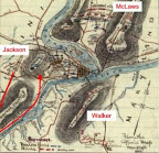
Confederate troops opened their siege of Harper’s Ferry in September 1862 with a three pronged effort to capture the commanding elevations surrounding the town. McLaws seized Maryland Heights to the north, driving the Federal garrison pell-mell down the slope and across the bridges to the town. Walker’s Division occupied Loudon Heights to the south. Jackson’s troops invested the Federal position on Bolivar Heights from Schoolhouse Ridge to the west.
I first hiked along the Federal skirmish line between Bolivar Heights and North Schoolhouse Ridge, where three green New York regiments spent an uneasy night on the line awaiting a frontal attack that never came. Jackson had something else in mind. He sent a column under A. P. Hill to outflank Bolivar Heights from the south. Hill placed several batteries to enfilade Bolivar Heights, and after a sharp morning bombardment, his infantry started their advance. White flags appeared in the Federal lines as the infantry closed in.
On Bolivar Heights, Union Colonel Dixon S. Miles, commanding Harpers Ferry, determined further resistance was useless. Shortly thereafter, he was mortally wounded by one of the last salvos from the rebel artillery. The Federals never should have attempted to defend Harpers Ferry in the first place. Once the rebels seized Maryland and Loudon Heights, the contest was simply a matter of time. Looking from Bolivar Heights to the dominating summits of the other elevations to the east, the indefensibility of the post is clear. What McLellan may have done with the 12,000 troops surrendered here is a matter of speculation. He certainly made no strenuous effort to save them from the trap.
The trails along Bolivar Heights offer excellent views of Shoolhouse Ridge, Maryland Heights, and Loudon Heights. Take a map, and start at the Bolivar Heights area on Washington Street just off Route 340. I started my hike without a map from the Federal skirmish line area at the western end of Bolivar Heights, and ended up walking the trails between the two areas. The drive between is much easier, and you won’t miss anything. I plan to take in the southern end of Schoolhouse Ridge and Maryland Heights on my next visit.


2 comments:
That map is pretty neat. Where did it come from?
The map is from an online archive of the Library of Congress. I will try to remember to cite the sources for the maps I use in the future, and I am planning a post on map resources soon.
The archive can be found here:
http://memory.loc.gov/ammem/gmdhtml/milhome.html
They have a huge collection, including the Hotchkiss maps (Stonewall Jackson's cartographer).
Note I added the bold division names and the arrow marking AP Hill's flank movement.
Post a Comment