Thursday, July 31, 2008

Civil War Weekend 2008

Three weeks since my last post – please accept my apologies for such a long delay. I was busy preparing for Historicon, the largest historical miniatures wargaming convention in the USA. My other hobby is miniature wargaming and I also import several ranges of historical miniatures from the UK. Interestingly enough, I built a diorama of the action in the Forty Acre Cornfield at Antietam to display in my booth at the show. But enough on that – I may return to it later as a sidebar.

Tomorrow I leave for my annual Civil War weekend with my friend Matt, who has been touring battlefields with me since the early days. We are heading South, of course. The first stop is Bentonville, NC. I have purchased a copy of Mark Moore’s excellent guide and printed out full color maps for each tour stop from the battlefield web site. Time permitting (and the schedule is tight) we may get to Averasboro as well.

From North Carolina, we will head northeast to Newport News, Virginia. The Mariner’s Museum there houses the USS Monitor Center. Besides a full scale replica of the Monitor, the center contains many artifacts from the wreck of this most famous of ironclads, including a significant portion of the turret. Side excursions will include Gaines Mill, Glendale, and Malvern Hill as time allows.

On Sunday, we head west to Pamplin Park, located on the site of the April 2, 1865 breakthrough that shattered Lee’s Petersburg defenses and precipitated his retreat to Appomattox. Pamplin Park contains the National Museum of the Civil War Soldier, where visitors follow the experiences of a single soldier through the war and a series of interactive exhibits. The park also features a section of reconstructed works, including trenches and abatis, as well as several trails interpreting the site of the breakthrough.

On the way home, I hope to stop off at the North Anna Battlefield Park. This may be overly ambitious, but I am hopeful nonetheless. I expect this weekend to provide material for many posts in the weeks to come.

Monday, July 7, 2008

The Siege of Harpers Ferry


Harper’s Ferry offers a unique combination of scenic beauty, history, and entertainment. It’s a great place for a day trip. In fact, I drove to Harper’s Ferry twice over July 4th weekend. To be honest, the first trip was a washout – it poured from the minute I crossed into West Virginia. Since we live less than an hour away, I decided to try again the next day.

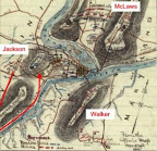
Confederate troops opened their siege of Harper’s Ferry in September 1862 with a three pronged effort to capture the commanding elevations surrounding the town. McLaws seized Maryland Heights to the north, driving the Federal garrison pell-mell down the slope and across the bridges to the town. Walker’s Division occupied Loudon Heights to the south. Jackson’s troops invested the Federal position on Bolivar Heights from Schoolhouse Ridge to the west.

I first hiked along the Federal skirmish line between Bolivar Heights and North Schoolhouse Ridge, where three green New York regiments spent an uneasy night on the line awaiting a frontal attack that never came. Jackson had something else in mind. He sent a column under A. P. Hill to outflank Bolivar Heights from the south. Hill placed several batteries to enfilade Bolivar Heights, and after a sharp morning bombardment, his infantry started their advance. White flags appeared in the Federal lines as the infantry closed in.

On Bolivar Heights, Union Colonel Dixon S. Miles, commanding Harpers Ferry, determined further resistance was useless. Shortly thereafter, he was mortally wounded by one of the last salvos from the rebel artillery. The Federals never should have attempted to defend Harpers Ferry in the first place. Once the rebels seized Maryland and Loudon Heights, the contest was simply a matter of time. Looking from Bolivar Heights to the dominating summits of the other elevations to the east, the indefensibility of the post is clear. What McLellan may have done with the 12,000 troops surrendered here is a matter of speculation. He certainly made no strenuous effort to save them from the trap.

The trails along Bolivar Heights offer excellent views of Shoolhouse Ridge, Maryland Heights, and Loudon Heights. Take a map, and start at the Bolivar Heights area on Washington Street just off Route 340. I started my hike without a map from the Federal skirmish line area at the western end of Bolivar Heights, and ended up walking the trails between the two areas. The drive between is much easier, and you won’t miss anything. I plan to take in the southern end of Schoolhouse Ridge and Maryland Heights on my next visit.